1. Introduction
Nowadays, urbanization has found a key role in our lifetime that the understanding of urban growth could be the ability to plan the future directions this issue caused with urbanization being a variable and complex phenomenon. Cities with permanent changes are living organisms that require this transformation design solution for structural and social demands to achieve safe and healthy human contacts (Önder, D.E., Gigi, Y. , 2010). Some scholars divide cities sustainable development toward two main views, as the building's set are connected by a space, on the other hand human social actions are linked by urban network interaction. Urban networks as a society infrastructure have a crucial role in reaching success and sufficient access to different resources (Vaughan, 2007).
The issue of predicting and providing is a base of the traditional view of transportation planning that in modern society has been discontinued. Recent studies have changed their design concept to numerical and computational by the establishment of mathematical and physical science. From this view, urban spaces could have the relation of a node structure. In this regards, the edge will find the main role with the complex network that has a close similarity to the other networks. (Levinson, 2006) (Cardillo, A., Scellato, S., Latora, V., Porta, S., 2006) (Yuan, P.C., Juan, Z.C., 2013).
The issue urban network analysis faces is with various issues like information, network communication and social issues but a new subject emerges as an urban road network analysis. Scientific studies on this issue bring a new view that a group of network nodes have more structural dates in comparison with a single one (Wagner, 2008) (Tischendorf, L., Fahrig, L., 2000). This subject begins from the logic of a space syntax, that urban road network are working as a body neural network where movement are employed make simple linear elements in the network that could be able to present line movement in the network system to find natural units (Jiang, B., Zhao, S., Yin, J., 2008). Space syntax emerged from the architectural view to an environment one as logic a analyze space. This fact has caused space syntax to follow both of architectural view and computational knowledge. However, this issue has theoretical base and mathematical principles in each case study (Thomson, 2006) (Hillier, B., Hanson, J., 1997) (Reveron, 2009).
The aim of this paper study on urban road network by the establishment of space syntax logic is that this issue is divided into two main parts. The first part: the study on an existing one and allowing the new suggestions to achieve a more qualified urban road network. The second part: is a study by the municipality of Sari city for future urban projects. This study is planned to examine the new projects by comparing them with the previous one to find the true results of the differences. In this regards, the first result is achieved by employment of Depthmap software and the second result is continued by the establishment of SPSS for further research.
2. Methodology
This study has developed two methods to analyze the case study. As it mentioned, the main one is with space syntax to examine the existing conditions with the suggested one. SPSS was employed as a second method to reach a deeper analysis by using the numerical result of the first method.
2.1. Space syntax
Space syntax is an analysis method that conceived and developed by Bill Hillier and Julienne Hanson in late of the 1970s. The method could be established on urban issues, such as studying urban space, reading and prediction. While this method of space syntax is functional for urban reading, it also would be helpful for an association between physical and social structure (Hillier, B., Hanson, J., 1997) (Duan, Y., Lu, F., 2013).
Bill Hillier as the leader of space syntax logic believes, mostly cities are found by general view but syntactic analysis of cities say that there are hidden physical movements and structures (Stahle, A., Marcus, L., Karlström, A., 2005). Space syntax was born based on graph theory by classifications of urban environment split into single parts to study their existing relations. In this regards, space syntax could examine different points based on space geometrical logic to reach hidden systems and structures of human environments (Steadman, 1983) (Peponis, J.C., Wineman, J., Bafna, S., 1998) (Penn, 2003).
This logic could be functional in studying urban contextual features which in this issue, axial lines establish the main role. The axial map in space syntax logic has the fewest set of straight lines that curve out in convex space (Tianxiang, Y., Dong, J., Shoubing, W., 2015) (Hillier, 2007). In a set of the convex map the axial line brings the shortest space to coating the whole space. Bill Hillier in "The social logic of Space" defined an axial line as a pathway to move in unblocked space (Hargrove, W.W., Hoffman, F.M., Efroymson, R.A., 2004). This concept believes each link is an axial line and each connection with other lines could be as an intersection which shows the spatial relation between lines and nodes (Tianxiang, Y., Dong, J., Shoubing, W., 2015) (Hillier, B., Hanson, J., 1984). There are many axial lines in urban spaces while there are few groups of axial lines in an axial map that pass through the whole city; they could be reachable in any way on an axial map while joined with the disjoint parts just by a third axial line. The dynamic lines were born with intentions to break boundaries (Jiang, B., Claramunt, C., Klarqvist, B., 2000) (Hillier, 2007). The topological network parameters such as total depth, integration could be obtained by line connection to urban nodes with the links meeting at a junction (Önder, D.E., Gigi, Y. , 2010) (Rezayan, H., Delavar, M.R., Frank, A.U., Mansouri, A., 2010) (Hillier, B., Hanson, J., 1984).
2.2. SPSS
As is mentioned, the second method of this study is the SPSS. This method was employed to reach more a complete result by a numerical analysis of space syntax. This part of the study, same as the previous part is based on differences of two conditions, the existing and suggested ones. The SPSS method was employed based on the T-Test concept ( Fritz, M., Berger, P., 2015) (Plume, 2003) ( Landau, S., Everitt, Brian., 2004).
3. Result
The case of Sari city in Iran has interesting issues to study on the urban road network. As is mentioned, the municipality of Sari created new projects to add more accessibility to the whole of the city. They aim is to get more integration and reduce the depth of places. In this regards, the new projects are studied to apply for this aim, ring roads and some streets inside of the city that are following the main aim. This paper is plans to compare the existing condition with further projects.
This study by the establishment of space syntax has mentioned some specific parameters, such as integration, total depth, and connectivity. These will be studied by comparing both the conditions past and future.
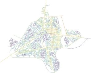
In existing condition the average rate of integration on a local scale (R5) is 1.38 also the maximum and minimum, respectively is 2.63 and 0.34 which in the suggested plan, the average has growth to 1.43 with 0.05 unit increase also maximum integration is 2.64 but the minimum has not any change. On the other hand, the global scale (R10) has changed as well. In the scale of R10, the average of integration is 1.08 and the maximum is 1.54 also the minimum is 0.38 with the changes, the differences is impressive. By the new plan, the average of integration is 1.43 with 0.35 units increase and the maximum is changed to 2.64, (Figure. 1), (Figure. 2).
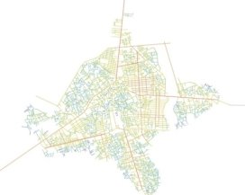 a )
a ) b )
b )
Figure 1. Urban road integration of existing condition in scale R5 (a) and R10 (b)
 a)
a) 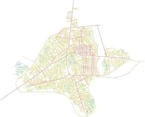 b)
b)
Figure 2. Urban road integration of future plan scale R5 (a) and R10 (b)
Connectivity is another factor for study in this paper. In existing conditions, the average of connectivity is 2.63 with the minimum rate of 1 and maximum rate of 47. But with suggested plan, just the average has changed with 0.07 unit's growth to be 2.70. The total depth of the integration and connectivity has changed in both of R10 and R5. The average total depth of R5 in existing condition is 722.61 with the maximum rate of 3426 and minimum of 15. But with the new plan, it has changed and the average of total depth is increased to 817.07 with 94.46 units increase also the maximum has increased to 3511, it means 85 units growth but in both conditions the minimum total depth has no changes, (Figure. 3), (Figure. 4).
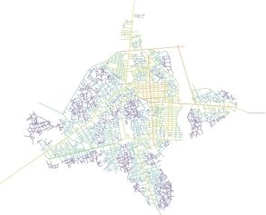 a)
a) 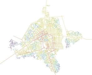 b)
b)
Figure 3. Urban road total depth of existed condition in scale R5 (a) and R10 (b)
 a)
a)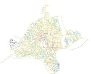 b)
b)
Figure 4. Urban road total depth of future plan in scale R5 (a) and R10 (b)
In analyzing of the scatter plot, the R2 in condition of connectivity and R10 is 0.10163 and with R5 is 0.18168 but with the new plan, the R10 has changed to 0.11169 also R5 is changed to 0.18430. The rate of R2 in the condition of integration and R10 in the existing plan is 0.898719 and with R5 it is 0.7112 but with the suggested plan, it has changed in R10’s scale to 0.891439 with 7280 unit decrease but for R5 there is 84 unit increase and it gets to 0.7196.
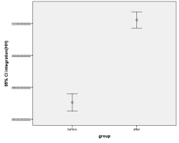
In the second part, the numerical results received go to the space syntax are established by SPSS to analyze the integration differences and total depth in local and global dimensions. The final results show the meaningful differences in how the suggested project can be useful to improve the urban accessibility condition. The SPSS study based on test significance from global integration shows the R10 integration average is 0.870 in the existing issue which is increased to 0.922 in the second group as a new plan means the difference is shown about -0.0517. In the same way, the R5 study, integration has positive changes like R5 integration. In the existing tissue, R5 integration has the rate of 1.389, even though in the suggested plan, it is increased to 1.437. The mean of the difference in R5 integration is - 0.0476. The “T-value” index in R10 integration test is -13.508 with the free degree of 6104.432. Also in R5 integration, the “T-value” is -4.735 which shows the significant difference between the average amount of R5 integration in group one and two with 6109.397 freedom degree, (Figure. 5).
 a)
a)  b)
b)
Figure 5. Graph of integration for existing and future condition of R5 (A) and R10 (B)
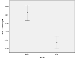
The total depth of R10 in the previous condition had the rate of 35312.89. However, by increasing the integration, it would decrease to 34424.92 in the following condition. The total R5 depth is 722.62 in the existing issue and in the suggested plan; it is changed to 811.90, (Figure, 6).
 A
A 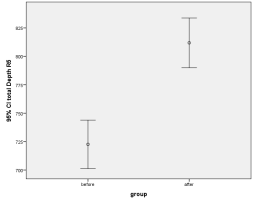 B
B
Figure 6. Graph of total depth for existing and future condition of R10 (A) and R10 (B)
By comparing the total depth in both conditions, the total depth in versus R10 has a positive result with a significant difference of -887.97. This index in the R5 scale has a negative growth around -89.28. It is shown, by the new plan when the whole integration has grown, the place’s depth could be grow up but in the case of Total R5 depth, the result has a negative rate because of increasing the connection numbers. It can be said, the previous condition has lower depth than the suggested plan, (Table 1).
Table 1. Table of Independent sample test by SPSS.

As mentioned, “T-value” has a negative rate in both shown integrations, the suggested plan has a good result, but by means of the total depth index, just global scale is acceptable with the positive change rate of 5.807 and in R5 scale, this rate is -5.736 which shows the place’s depth is increased.
4. Conclusion
This study has established the space syntax and SPSS, to study the new projects by comparing the existing one that was defined by municipality Sari city, by the new project rate of integration it is increased in global scale (R10) also in local one (R5) but in issue of total depth, there is growth it could be a negative point, because based on the logic of space syntax, in successful projects, when the integration has growth, the total depth should shrink.
While the new projects numerical differences are not significant, the suggested designs could bring some changes which are a positive, because this method could be applicable to other subjects. This study attempted to examine the differences between the new projects and define some useful ways to improve urban infrastructure.
Acknowledgments
This research did not receive any specific grant from funding agencies in the public, commercial, or non-for-profit sectors.
References
Fritz, M., Berger, P. (2015). Chapter 3 – Comparing two designs (or anything else!) using paired sample T-tests. Improving the User Experience Through Practical Data Analytics, 71 - 89.
Landau, S., Everitt, Brian. (2004). A Handbook of Statistical Analyses using SPSS. London: CHAPMAN & HALL/CRC Press.
Cardillo, A., Scellato, S., Latora, V., Porta, S. (2006). Structural properties of planar graphs of urban street patterns. Physical Review E73, 66 - 107.
Duan, Y., Lu, F. (2013). Structural robustness of city road networks based on community. Computers, Environment and Urban Systems 41, 75 – 87.
Hargrove, W.W., Hoffman, F.M., Efroymson, R.A. (2004). A practical map analysis tool for detecting potential dispersal corridors. landscape Ecology 20, 361 – 373.
Hillier, B. (2007). Space Is the Machine: A Configurational Theory of Architecture. London: Space Syntax, University College London.
Hillier, B., Hanson, J. (1984). The Social Logic of Space. Cambridge: Cambridge University Press.
Hillier, B., Hanson, J. (1997). The Reasoning Art: Or, the Need for an Analytic Theory of Architecture. Proceedings, 1st International Space Syntax Symposium (pp. 01.1 - 01.5). London: University College London.
Jiang, B., Claramunt, C., Klarqvist, B. (2000). An integration of space syntax into GIS for modeling urban spaces. International Journal of Applied Earth Observation and Geoinformation 2, 161 – 171.
Jiang, B., Zhao, S., Yin, J. (2008). Self-organized natural roads for predicting traffic flow: A sensitivity study. Journal of Statistical Mechanics: Theory and Experiment 7 , P07008 , 1 - 23.
Levinson, D. (2006). Self-Organization of Surface Transportation Networks. Transportation Science 40, 179 - 188.
Önder, D.E., Gigi, Y. . (2010). Reading urban spaces by the space-syntax method: A proposal for the South. Cities 27 , 260 – 271.
Penn, A. (2003). Space syntax and spatial cognition or why the axial line? . Environmental Behaviour 35, 30 – 65.
Peponis, J.C., Wineman, J., Bafna, S. (1998). On the generation of linear representations of spatial configuration. Environment and Planning B: Planning and Design 25, 559 - 576.
Plume, M. (2003). SPSS (Statistical Package for the Social Sciences). Encyclopedia of Information Systems, 187 - 196.
Reveron, F. O. (2009). Developing Spatial Configuration Abilities Coupled with the Space Syntax Theory for First Year Architectural Studies. Proceedings of the 7th International Space Syntax Symposium (pp. 082:1 - 10). Stockholm: University Collage London.
Rezayan, H., Delavar, M.R., Frank, A.U., Mansouri, A. (2010). Spatial rules that generate urban patterns: Emergence of the power law in the distribution of axial line length. International Journal of Applied Earth Observation and Geoinformation 12, 317 – 330.
Stahle, A., Marcus, L., Karlström, A. (2005). Geographic Accessibility with Axial Lines in GIS. Proceedings of the 5th International Space Syntax Symposium (pp. 131 - 144). Stockholm: KTH School of Architecture.
Steadman, P. (1983). Architectural Morphology: An Introduction to the Geometry of Building Plans. London: Pion Limited Press.
Thomson, R. C. (2006). The ‘stroke’ concept in geographic network generalization and analysis. Progress in Spatial Data Handling, 681 – 697.
Tianxiang, Y., Dong, J., Shoubing, W. ( 2015). Applying and exploring a new modeling approach of functional connectivity regarding ecological network: A case study on the dynamic lines of space syntax. Ecological Modelling, 126 - 137.
Tischendorf, L., Fahrig, L. (2000). On the usage and measurement of landscape connectivity. Oikos 90, 7 - 19.
Vaughan, L. (2007). The spatial syntax of urban segregation. Progress in Planning 67 , 205 – 294.
Wagner, R. (2008). On the metric, topological and functional structures of urban networks. Physica A 387 , 2120 – 2132.
Yuan, P.C., Juan, Z.C. (2013). Urban road network evolution mechanism based on the ‘direction preferred connection’ and ‘degree constraint’. Physica A 392 , 5186 – 5193.
How to Cite:
Valipour, E., Tayyebisoudkolaei, S., & Mobaraki, A. (2017). Establishment of space syntax to read urban road network; the case of Sari, Iran. Journal of Contemporary Urban Affairs, 1(2), 69-75. https://doi.org/10.25034/ijcua.2017.3649
This work is licensed under a Creative Commons Attribution - NonCommercial - NoDerivs 4.0.
"CC-BY-NC-ND"