How to Cite this Article:
VALIPOUR, E., MOBARAKI, A., NIKOOFAM, M., & TAYYEBISOUDKOLAEI, S. (2019). Establishment of Space syntax to read and analyze urban network; the case of study, Famagusta city of Cyprus. Journal of Contemporary Urban Affairs, 3(1), 154-160. https://doi.org/10.25034/ijcua.2018.4692
Journal Of Contemporary Urban Affairs
2019, Volume 3, Number 1, pages 154– 160
Establishment Of Space Syntax To Read And Analyze Urban Network; The Case Of Study, Famagusta City Of Cyprus
* Ph.D. Candidate EHSAN VALIPOUR 1, Ph.D. Candidate ABDOLLAH MOBARAKI 2
Ph.D. Candidate MOJDEH NIKOOFAM 3, B.A SAMIRA TAYYEBISOUDKOLAEI 4
1 & 2 Faculty of Architecture, Cyprus International University, Nicosia, Mersin 10 Turkey
3 Faculty of Architecture, Eastern Mediterranean University, Famagusta, Mersin 10 Turkey
4 Islamic Azad University, Iran
Email: eh.valipour@gmail.com Email: a_mobarakie@yahoo.com Email: mojdeh.nikoofam@gmail.com
*Corresponding Authors
Faculty of Architecture, Cyprus International University, Nicosia, Mersin 10, Turkey
E-mail address: eh.valipour@gmail.com
A R T I C L E I N F O:
Article history:
Received 24 December 2017
Accepted 05 February 2018
Available online 05 August 2018
Keywords:
Space syntax; studying spaces; urban road network; Famagusta city.
A B S T R A C T
Architects and designers should be familiar with the city developmental process to know about all the city aspects if they are hidden the whole time. This matter shows the importance of studying the urban sections to find out the city critical points. The method is the space syntax in one view which is the consideration of urban network analysis and it would be presented by graphs and maps by a computational description of the selected places. The main target of the space syntax establishment is to study the urban network issue by clarifying the most logical routes in the urban road network. This study has the aim to implement the space syntax as a method to determine urban network problems in order to achieve the new suggestions to increase the urban network integration. In this regards, Famagusta city in Cyprus is chosen to study to present the new suggestion.
JOURNAL OF CONTEMPORARY URBAN AFFAIRS (2019), 3(1), 154-160. https://doi.org/10.25034/ijcua.2018.4692
www.ijcua.com
Copyright © 2018 Journal Of Contemporary Urban Affairs. All rights reserved.
1. Introduction
As live organisms, the Cities are in permanent transformations. So, this development asks for suitable design solutions to respond the structural and social demands to make human contacts safe and healthy (Önder, D.E., Gigi, Y. , 2010). Scholars division about cities sustainable development consists of two main issues. As the huge building's collections are linked by a space, the human activity system is also connected by the urban network interaction (Vaughan, 2007).
Recently, most studies have changed their directions towards using more physics, mathematics, computer science and mechanics etc. Considering this matter, the urban space may access the network by a node structure. Then the edge has a bold position as a complex network with a close similarity to the other networks, for instance, a cooperative relation network with a specific structure by its own (Levinson, 2006 ;Cardillo, A., Scellato, S., Latora, V., Porta, S., 2006; Yuan, P.C., Juan, Z.C., 2013).
The history of urban network analysis is included various issues such as social, informational and communicational networks but nowadays, there is a new issue in this context as the analyze of the urban road network (Wagner, 2008). Scholars' studies show
that the groups of connected nodes have more structural data in compare with the single ones. For instance, to find knot or stroke in a city access network is a group of consecutive road parts which has an effect on the street length (Jiang, B., Zhao, S., Yin, J., 2008). Mainly, this issue has started from space syntax to show the urban road network could be like body neural network in which stroke has employed to make linear elements relatively simple and understandable in networks which would be able to show lines movement in network frame and to build natural functional units (Duan, Y., Lu, F., 2013).Space syntax is born inside the architecture as a spatial analysis theory. It has followed both the architecture field and knowledge. In addition, it has contained philosophy and mathematics, on one side as well as the other sciences on the other side. However, it also contains the philosophical base and mathematical principles in the evaluation cases (Hillier, B., Hanson, J., 1997; Reveron, 2009).
The aims of this study would be divided into two main parts, the first one is to study and identify the existed urban network and the second part is to propose some new connections to reach the qualified urban network as a suggestion. This study is planned to compare the present position and the suggested condition by pretending two selected methods. The first method is Space syntax logic employed by Depthmap software and the second one is SPSS establishment reached the numbers from the first part of the analysis. As a case study, the newly developed area of Famagusta in Cyprus is selected due to various reasons, such as dense settlements, urban traffic and being close to some places like commercial centers and EMU University campus. This paper has planned to review the literature and regional observations. It has also planned to identify the problematic points and deep place understanding. Based on these, suggestions are planned to diminish recognized problems about the selected area with the aim to grow the network quality in the selected region.
2. Methodology
Based on the regular viewpoint, Bill Hillier says “cities seem that could be seen but cities syntactic analysis shows that it has made to provide physical movements and being understandable to minds”(Stahle, A., Marcus, L., Karlström, A., 2005). Space syntax follows the principles of the graph theory by dividing the urban space into the single units to analyze their relationship with the other parts. Space syntax covers the various points based on space geometrical logic which can discover the invisible seated structure in the human environment. (Steadman, 1983; Peponis, J.C., Wineman, J., Bafna, S., 1998)(Penn, 2003)(Turner, 2003; Hillier, 2007; Tianxiang, Y., Dong, J., Shoubing, W., 2015).
This concept could be useful to study urban contextual features by an axial line employment as one of the main theory columns. The axial space map would have the fewest set of straight lines which cross via convex space. The collection of all axial lines and convex maps would have the fewest space collection to cover the whole space (Hillier, B., Hanson, J., 1984; Önder, D.E., Gigi, Y. , 2010; Rezayan, H., Delavar, M.R., Frank, A.U., Mansouri, A., 2010). In “The Social Logic of Space” Bill Hillier has defined (Hillier, B., Hanson, J., 1984) axial line presents the pathway of unblocked movement. In this concept, each path could be as an axial line and the linked by the other lines as intersections. It could be defined there is a spatial correlation between lines roots with each other. The Urban spaces are contained many numbers of axial lines while the axial maps are contained just fewest groups of axial lines which pass the city; they could be visible everywhere on the axial line map like any other disjoint parts or points which can be joined by the third axial line (Wagner, 2008; Han, Y., Jin-yeu, T., Jiangang, L., 2009; Hillier, B., Hanson, J., 1984; Tischendorf, L., Fahrig, L., 2000; Hargrove, W.W., Hoffman, F.M., Efroymson, R.A., 2004). The dynamic lines idea is shaped based on the breaking conception of boundaries. Multiple lines of different lengths have functioned to represent the detailed and specific Euclidean agent’s geometry of agents reflected in the free space. By connection lines to the nodes and their junction to the links, it would be possible to obtain the topological network parameters by defining the Total Depth, Integration, etc. (Jiang, B., Claramunt, C., Klarqvist, B., 2000; Hillier, 2007).
3. Famagusta as a case study
Famagusta city is located in the East of Cyprus on the Mediterranean coast. It is one of the Cyprus historical cities. The core castle had a bold role during the medieval era. In British colony period, Famagusta was focused on tourism and commercial destinations. This fact made the city walls continue to the outer part in Ottoman period. In 1974, this city experienced the civil war which occurred between the Greek residents and the Turkish people with the support of Turkey government. This war has resulted in the border between these two parts in the South. This matter has caused the development direction has changed from South to North. By developing the North part in Famagusta, Eastern Mediterranean University was established in the middle of two main roads to be accessed by the Northern cities. As mentioned, the university campus is located in the middle of two main roads. This blocked area prevents the direct access to the side roads. By further city development, free lands around the university campus have been built by the high-density inhabitants and commercial units. This kind of inhabitants compress has caused some problems such as pollution and traffic. This study follows the important points on how it would be beneficial to access the university campus as well as the completion of existed urban network. Fig 1 has defined some different regions in the selected area of Famagusta as a case study.
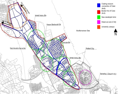
Figure 1. Selected area in Famagusta as a case study
4. Discussion and results
In order to understand the space physical features to examine features effects on human movements, an axial map of selected area is evaluated by employing Depthmap software. This study has a specific view on integration factor in Rn scale as a global integration and also R5 for local dimension.
The case study area has located in the middle of Gazi Mustafa Kamal Blv and Ismet Inonu Blv, which is in Hasan Barbocolli Sk neighborhood. The interface region between Gazi Mustafa Kamal Blv and Ismet Inonu Blv has a high potential to increase Rn and R5 rate by adding some new connections but unfortunately, as it is mentioned, Hasan Barbocolli Sk can be an example with just a few connections. As fig 1 shows, there are some organic urban patterns in this area and also some free lands that could complete their connections to reach the highest integration.
This study has two main areas and each of them has a kind of specific importance. The primary area is from the university campus to Topular Blv and the second region is from Topcular Blv to Walled city. The first region has more commercial values with most of the economical sources including the university campus. The Eastern Mediterranean University campus has an effective role in this region because of scale and location. Unfortunately, there is a problem with the university campus because the availability is hard to get, in the late evening as well as missing some connections to the side roads. Actually, university campus has the potential to play a more effective role to increase the integration of Gazi Mustafa Kamal Blv and Ismet Inonu Blv. University campus has inner streets which are not connected to the mentioned roads, although this potential could be useful to the residences to reach the Gazi Mustafa Kamal Blv and Ismet Inonu Blv via campus, fig 2.
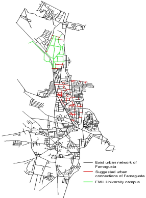
Figure 2. Axial map of the existing pattern and the suggested project.
The Second region in the case study is ended in Walled city. This area which is across from the northern part has more houses and population density. There are many connections remained undone so building them wholly can be effective in the integration of this region with Gazi Mustafa Kamal Blv and Walled city.
Mentioning the aim of this study, Famagusta axial map is established to make the analyzed selected area. As figure 2 shows, the green line is the university campus that is joined to existed urban tissue by the suggested line in red color.
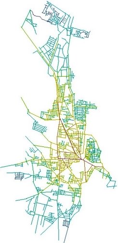
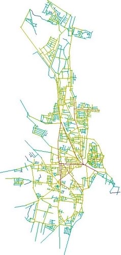
Figure 3. The axial map in the present condition and Rn values. Figure 4. Axial map at the present condition and R5 values

In order to evaluate the differences between exist condition (fig 3, 4) and suggested plan (fig 5, 6), the axial map of the case study is established in this study mentioning two different scales, global integration value (Rn) and also the local one (R5).
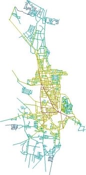
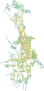
Figure 5. Axial map of suggested connection and Rn values. Figure 6. Axial map of suggested connection and R5 values
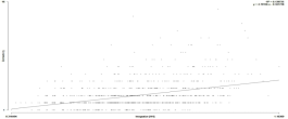
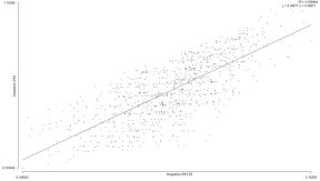
The R2 rate (determination efficiency), a value of global integration (HH) and the connectivity are 0.104 in the present issue. In the suggested project, this rate is increased to 0.139 and, R2 is 0.511 between the integration (HH) R5 and integration (HH) in the existed pattern, although the new pattern has been changed to 0.580.
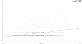
Graph 1. Rn Scattergram in the present tissue, value (R2: 0.104)
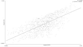
Graph 2. R5 Scattergram in the present tissue, value (R2: 0.511)
Graph 3. Rn Scattergram in the suggested project, value (R2: 0.139)
Graph 4. R5 Scattergram in the suggested project, value (R2: 0.580)
Attributed properties of this study have clarified; the average of R5 is 1.23 in the existed pattern, although, in the suggested project, it is increased to 1.28. The maximum R5 value is 2.11 in the existed tissue, but in the new pattern, it is changed to2.16. In contrast with the maximum value, the R5 minimum does not have any change. In Rn study, the average of the present tissue is increased from 0.682916 to 0.71466. In the global integration, the maximum value is changed from 1.13763 to 1.16369 and for the minimum value; there is also change from 1.13763 to 1.16369.
5. Conclusions
This study is employed by the space syntax and SPSS methods to analyze the newly developed area of Famagusta before and after project implementation which may propose to resolve some identified problems. While in the current tissue, the urban networks are concentrated with low rate value integration, the proposed changes can make more accessibility with higher integration and the lowest places depth. This would significantly improve the overall experience of the area, as illustrated by improvements in the global integration value (Rn) from 0.68 to 0.71. Similarly, the local integration value (R5) would be increased from 1.23 to 1.28 and also the total depth would be decreased in the global scale from 13593.12 to 13201.06, but just the total R5 depth is increased from 307.65 to 374.06.
Here is an emphasis while this is not a significant numerical change; the intelligibility level can be changed by the application of the suggested design. The results are also important because the method is applicable to other problematic areas. This study has tried to propose some new suggestions to improve the physical and economic values of the case study by more accessibility also it wants to be useful for the city infrastructure and superstructure.
Acknowledgements
This research did not receive any specific grant from funding agencies in the public, commercial, or not-for-profit sectors.
Conflict of interests
The authors declare no conflict of interest.
References
Peponis, J Wineman, S Bafna, M Rashid, S H Kim. (1998). On the generation of linear representations of spatial configuration configuration. Environment and Planning B: Planning and Design , 559 – 576. https://journals.sagepub.com/doi/10.1068/b250559
Alasdair Turner, Alan Penn, Bill Hillier. (2005). An algorithmic definition of the axial map. Environment and Planning B: Planning and Design 32,3 , 425 - 444. https://ideas.repec.org/a/pio/envirb/v32y2005i3p425-444.html
Alexander Stahle, Lars Marcus. (2005). Place Syntax, Geographic Accessibility with Axial Lines in GIS. Stockholm, Sweden: KTH School of Architecture. https://www.diva-portal.org/smash/get/diva2:469861/FULLTEXT01.pdf
Alexander, C. (1973). Notes on the synthesis of form. Cambridge, Massachusetts: Harvard University Press https://monoskop.org/images/f/ff/Alexander_Christopher_Notes_on_the_Synthesis_of_Form.pdf
Bill Hillier, Julienne Hanson. (1984). Social logic of space. Cambridge, UK: Cambridge University Press https://www.researchgate.net/publication/238786191_The_Social_Logic_of_Space
Bill Hillier, Laura Vaughan. (1970). The City as One Thing.London https://pdfs.semanticscholar.org/f391/45293ebb4fef5608434e66b62204d0e4a6d8.pdf
DenizErinselÖnder ,Yıldırım Gigi. (2010). Reading urban spaces by the space-syntax method: A proposal for the South Region, Haliç. Cities 27 , 260 – 271. http://papers.cumincad.org/data/works/att/ecaade2009_160.content.pdf
Habermas, J. (1984). The theory of Communicative Action. London: Heinemann Press. http://www.dphu.org/uploads/attachements/books/books_2795_0.pdf
Hapio, A. (2012). Towards sustainable urban communities.Environmental Impact Assessment Review 32 , 165 – 169. http://portal.research.lu.se/ws/files/5896149/8257947.pdf
Hilier. (2001). A theory of the city as object: or, how spatial laws mediate the social construction of urban space. 3rd International Space Syntax Symposium Proceeding. Atlanta, Georgia,USA. http://discovery.ucl.ac.uk/1029/
Hilier, B. (1996). Space is the Machine: A Configurational Theory of Architecture. Cambridge, UK: Cambridge University Press . nhttp://discovery.ucl.ac.uk/3881/1/SITM.pdf
HILLIER. (2008). BILL HILLIER MAPPING METHOD: Basis Of Space Syntax Technique. London: Space Syntax laboratory. http://www.cpas-egypt.com/pdf/Abd_ElBaser/M.SC/004.pdf
Hillier. (2003). The Knowledge that Shapes the City: The Human City beneath the Social City. Proceedings of the 4th International Symposium in Space Syntax, (pp. 1 - 20). London . https://pdfs.semanticscholar.org/66ca/725f31119d7307bb32ee101f53978f9ec47d.pdf
Hillier, B., J. Hanson. (1997). The Reasoning Art: Or, the Need for an Analytic Theory of Architecture. Proceedings.1st International Space Syntax Symposium, University College London, (pp. 11 - 15). London. https://www.ucl.ac.uk/bartlett/architecture/research/space-syntax-laboratory/1990s
Imad Al-Hashim, Mohammed Mansour. (2014). Developing a morphology-based Huff model using space syntax to analyse consumer spatial behaviour: A case study of Amman. The Journal of Space Syntax , 255 - 271. http://joss.bartlett.ucl.ac.uk/journal/index.php/joss/article/view/186
Isaac Middle, PetaDzidic. (2014). Integrating community gardens into public parks: An innovative approach for providing ecosystem services in urban areas. Urban Forestry & Urban Greening 13 , 638 – 645. https://www.researchgate.net/publication/266147854_Integrating_community_gardens_into_public_parks_An_innovative_approach_for_providing_ecosystem_services_in_urban_areas
KatarzynaSoleckaa, JacekŻakb. (2014 , July 2 - 4 ). Integration of the urban public transportation system with the application of traffic simulation. Transportation Research Procedia3 , pp. 259 – 268. https://www.sciencedirect.com/science/article/pii/S2352146514001689
Lefebvre, H. (1991). The Production of Space. Oxford: Blackwell Press . https://www.amazon.com/Production-Space-Henri-Lefebvre/dp/0631181776
Leslie Martin, Lionel March .(1972). Urban space and structures. Cambridge, UK: Cambridge University Press. https://trove.nla.gov.au/work/21275284?selectedversion=NBD107356
Pasaogullari,N., Doratli, N. (2004). Measuring accessibility and utilization of public spaces in Famagusta. Cities, Vol. 21 , 225 – 232.
https://www.academia.edu/1086175/Measuring_accessibility_and_utilization_of_public_spaces_in_Famagusta
Penn, A. (2003). Space syntax and spatial cognition or why the axial line?Environ.Behav. 35 , 30 - 65.
http://discovery.ucl.ac.uk/3420/
Pieter Valkering ,CarijnBeumer. (2013). An analysis of learning interaction in a cross-border network for sustainable urban neighborhood development .Journal of Cleaner Production 49 , 85 - 94. https://www.researchgate.net/publication/264218712_An_analysis_of_learning_interactions_in_a_cross
Read, S. (2013). Intensive urbanization: Levels, networks and central places. Journal of Space Syntax 4 , 1 - 17. http://joss.bartlett.ucl.ac.uk/journal/index.php/joss/article/view/160
Reveron, F. O. (2009). Developing spatial configuration abilities coupled with the Space Syntax Theory for first year architectural studies. Proceedings of the 7th International Space Syntax Symposium, (pp. 082:1 - 10). Stockholm. http://www.sss7.org/Proceedings/10%20Architectural%20Research%20and%20Architectural%20Design/082_Reveron.pdf
Rien van Stigt, Peter P.J. Driessen, Tejo J.M. Spit. (2013). A window on urban sustainability Integration of environmental interests in urban planning through ‘decision windows’. Environmental Impact Assessment Review 42 , 18 – 24. https://www.osti.gov/biblio/22246891
SebnemOnal, UgurDagli, NaciyeDoratli. (1999). The urban problems of Gazimagusa (Famagusta) and proposals for the future. Cities, Vol. 16 , 333 – 351.
Steadman, J. (1983). Architectural Morphology: An Introduction to the Geometry of Building Plans.London : Pion Limited Press. https://www.academia.edu/1147143/The_Urban_Problems_of_Gazima%C4%9Fusa_Famagusta_and_Proposals_for_the_Future
Vaughan, L. (2007). Review the spatial syntax of urban segregation. Progress in Planning 67 , 205 – 294. http://discovery.ucl.ac.uk/3445/
Wagner, R. (2008). On the metric, topological and functional structures of urban networks.Physica A 387 , 2120 – 2132. https://ideas.repec.org/a/eee/phsmap/v387y2008i8p2120-2132.html
Walsh. (2007). The Re-emergence of The Forty Martyrs of Sebaste in the Church of Saint Peter and Paul, Famagusta, Northern Cyprus.Journal of Cultural Heritage 8 , 81 - 86. https://www.academia.edu/165279/Walsh_M._The_Re-Emergence_of_the _Forty_Martyrs_of_Sebaste_Journal_of_Cultural_Heritage_March_2007_
Walsh, M. (2005).A Gothic masterpiece in the Levant.Saint Nicholas Cathedral, Famagusta, North Cyprus.Journal of Cultural Heritage 6 , 1 – 6. https://vdocuments.mx/a-gothic-masterpiece-in-the-levant-saint-nicholas-cathedral-famagusta-north.html
Yang Tianxiang , Jing Dong. (2014). Applying and exploring a new modeling approach of functional connectivity regarding ecological network: A case study on the dynamic lines of space syntax. Ecological Modelling. https://ideas.repec.org/a/eee/ecomod/v318y2015icp126-137.html
YU Han , TSOU Jin-yeu. (2009). Space Syntax analysis of Foshan street network transportation in support historic area redevelopment.The 4th International Conference of the International Forum on Urbanism (IFoU), (pp. 687 - 696). Amsterdam. https://core.ac.uk/download/pdf/48548298.pdf
How to Cite this Article:
VALIPOUR, E., MOBARAKI, A., NIKOOFAM, M., & TAYYEBISOUDKOLAEI, S. (2019). Establishment of Space syntax to read and analyze urban network; the case of study, Famagusta city of Cyprus. Journal of Contemporary Urban Affairs, 3(1), 154-160. https://doi.org/10.25034/ijcua.2018.4692
This work is licensed under a Creative Commons Attribution- NonCommercial - NoDerivs 4.0.
"CC-BY-NC-ND"