1. Introduction
Tabriz is at the elevation of 1351.4 meters (4433.7 ft.) above sea level near Guru River, Aji River, Urmia Lake, Sahand volcanic cone and Eynali Mountain (Moosavi, 2011). Tabriz is the most populated city in the north-west of Iran (See Figures 1 & 2) with the urban population of 1545491 in 2013. (Census of the Islamic Republic of Iran, 2006). Tabriz is an industrial city especially in automobile, machine tools, refineries and petrochemical, textile and cement production. It is also an academic and cultural city in the north-west of Iran (Results of national 2007 census). In Tabriz native people speak Azerbaijani language and most inhabitants are familiar with the Persian language, which is the official language of Iran and the only language of education (East Azerbaijan Geography). From Atropates era, Tabriz was chosen as the capital by several rulers; since 1265 it was capital of Ilkhanid dynasty and during Ghazan Khan Era, which came into power in 1295, the city reached its highest splendor. During Kara Koyunlu dynasty from 1375 to 1468 and again during Ak Koyunlu dynasty within 1468 – 1501, Tabriz was the capital of Iran. Again in the Safavid period from 1501 until their defeat in 1555 it was the capital of Iran, and during Qajar dynasty from 1794 until 1925 it was the residence of Iranian Crown Prince (Wood and Tucker, 2006, p. 530; Tapper, 1974, p. 324.).
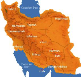
Figure 1. Location of Tabriz in Iran
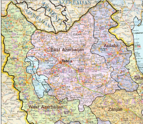
Figure 2. Location of Tabriz in East Azerbaijan Province (UNESCO, 2009).
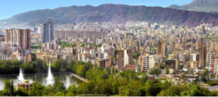
Figure 3. A Current Panorama of Tabriz
2. Population of Tabriz
Tabriz was the capital of the huge Mongol state headed by Ghazan Khan in 1295. In 1300 A.D. Tabriz was the fourth most populated city with a population of 125000 after Cairo, Paris, and Fez. In 1350 A.D. Tabriz was the fifth most populated city after Cairo, Paris, Fez, and Sarai. In 1400 A.D. Tabriz was the third most populated city after Cairo and Paris with a population of 150000, up by 50000 since 1350 A.D. despite its capture by Tamerlane. In 1450 A.D. Tabriz was the second most populated city with a population of 200000 after Cairo and again in 1500 A.D. Tabriz with a population of 250000 was the second most populated city after Cairo; Constantinople was third, Paris was fourth and the fifth place was held by Fez (Chase-Dunn and Willard, 1994, p. 104). Population of Tabriz was estimated to be 250000 in 1500 A.D. according to Tertius Chandler's table which is the fifth city among top ten cities of the year after Beijing, Vijayanagar, Cairo, and Hangzhou (Chandler, 1987). Although there are different ideas about being the second or the fifth most populated city in 1500 A.D. both have the same idea about the population of Tabriz. In 2013 urban population of Tabriz was 1545491 which is the third most populated city in Iran (Census – Natayej, 2012) (See Figure 3).
3. Earthquakes Happened in Tabriz
Tabriz is located in a seismically active area of Iran which has a very long history of producing earthquakes; the earliest one is recorded in 858 A.D. “Yahya Zoka” in his book “Earthquakes of Tabriz” mentioned forty historical earthquakes and described them with detail (Zoka, 1980, p. 5). Some of the worst earthquakes damaging Tabriz were the ones happened in 858, 1034, 1272 and 1780 A.D. The extent of the damage of the one happened in 858 A.D. is not known but it was significant. The one happened in 1034 A.D. killed 40000 people at midnight when Tabriz was the capital and the largest city of Azerbaijan. In 1272 A.D. an earthquake happened which was not as severe as the previous ones but still caused considerable damages. The largest and the most devastating earthquake happened in Tabriz was the one in 1780 A.D. on the first day of the New Year which destroyed most of the buildings (UNESCO, 2009).
4. Urban Quarters of Tabriz
Traditionally there are several Urban Quarters in Iranian cities, which do not have the same size and population necessarily. Each of these quarters is an urban-social unit which plays an important role in the organization of the social relations in the city. Some elements like cemeteries, general area and social applications of the quarter identify the quarter and determine political boundaries. There are different quarters in Tabriz because of various social backgrounds, migration and weather differences (UNESCO, 2009). Tabriz was divided into ten municipal districts and old districts are: Ahrab, Akhmagaya, Amragiz, Bahar, Baghmasha, Baghshoumal, Baron Avak (Barnava), Bazaar, Beylanki (Beylankooh), Charandab, Chousdouzan, Davachi, Gajil, Gazran (Renamed as Khayyam), Hokmavar, Imamieh, Kouchebagh, Khatib (Hatib), Khayyam, Khiyavan, Laklar, Lalah, Manzariya, Maghsoudia, Maralan, Nobar, Qaraghaj, Qaramalik, Rastakucha, Sarlak, Selab, Shanb-e-Ghazan, Shah-goli, Sheshghelan, Sirkhab, Tapalibagh and Vardjibashi (Vidjooya). Modern districts of Tabriz are Abrasan, Elahi Parast, Ferdous, Fereshteh, Golshahr, Marzdaran, Parvaz, Rajai Shahr, Roshdieh, Shahid Yaghchian, Valiye Asr and Zafaranieh (See Figures 4, 5, 6 & 7).
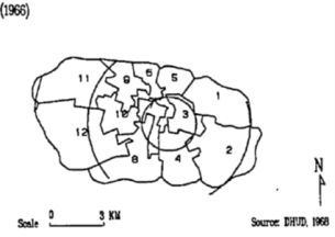
Figure 4. Zone Boundaries in Tabriz (in 1966) (Azimi, 1995, p. 64).
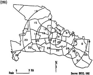
Figure 5. Zone Boundaries in Tabriz (in 1991) (Azimi, 1995, p. 64).
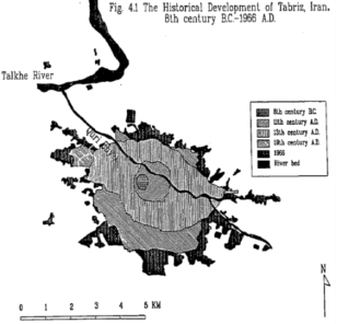
Figure 6. The Historical Development of Tabriz, Iran. 8th century B.C. – 1966 A.D. (Azimi, 1995, p. 70).
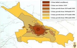
Figure 7. Periodic Growth of Tabriz City since the Formation of Initial Core until 2006 (Kheyroddin, et.al, 2013).
5. The Natural and Climate Characteristic of Tabriz
“Edwards” in his book “The Persian Carpet,” said: Tabriz, like most of other important cities of Iran, is at the junction of several roads where caravans pass. However, its importance is more than a connection center as it is located in the heart of a vast and fertile province of Azerbaijan and guards and protects one of the gates of Iran (Edwards, 1953, p. 62) (See Figure 8). “Chardin” the French explorer who visited Tabriz in the Safavid Period in his book “Chardin Itinerary,” said: The weather of Tabriz is cold and dry, yet so pleasant and healthy that it can work against bad moods and foul behavior. Cold weather exists for most of the year. Since the city is northerly, snow exists on the peaks of its mountains for nine months out of the year. The wind blows during mornings and nights, while rain showers form in all seasons except summer. The weather is relatively cloudy the entire year. Life is joyful and the food is plentiful (Chardin, 1956, p. 409) (See Figure 9).
Figure 8. The Map of Iran Plateau’s Folds (UNESCO, 2009).
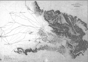
Figure 9. Map of Tabriz Drawn by Russian Engineers in Qajar Dynasty (UNESCO, 2009).
6. The Formation of Tabriz
“Tamer lane,” said: Tabriz contains such antiquity that nobody knows when it was first established (Brion, 1983, p. 127). Many resources in the middle ages believed that “Zobeide Khaton” wife of “Haroon-al-Rashid” Built Tabriz, other researchers say it goes back to the Median period. “Minoresky” believed the denomination of Tabriz goes before the Sassanid and Arsacid periods (UNESCO, 2009). “Giz”, the ambassador of England says that Tabriz is the same as “Kaza”, an ancient city, and forty years later “Flanden” claims some named Tabriz as “Kaza” (Etemād-olsaltaneh, 1878). “Hartsfield” believes that Tabriz is the same as “Taroni” which is mentioned by Sargon II (Sharokhin the second of Assyria 722 – 705 B.C.) (UNESCO, 2009). Archeological researches in Tabriz revealed the Grey Pottery Civilization around the eastern gate of Tabriz next to the Blue Mosque (a part of Silk Road) where there are thirteen historical eras such as Iron Age one to three, from Achaemenid to Islam period and beyond. Some parts remain from Bronze Age which proves that the history of Tabriz goes back to ca. 1500 B.C. (Hezhabr Nobari, 1999 – 2000) (See Figures 10, 11 & 12).
7. The History of Tabriz in the Islamic Era.
7. 1. 9th Century to 12th Century.
The core of the city of Tabriz at this time was a place with a Jame Mosque and a bazaar and the development of the city was due to them and government houses as ruling centers (Morris, 2002, p. 32). “Ravad Ibn-e-Almosanna-alazadi” who became the ruler of Tabriz selected Tabriz as his residence. At that time Tabriz was a small town and then, his son, “Vajna” and his brother built Tabriz and afterward “Ala Ibn-e-Ahmad Ravadi-alazadi” rebuilt Tabriz and made gates. There is a gate named “Ala” which is named after him (Sotoudeh, 1983, p. 92). In the early 9th century there was a solid castle in Tabriz which “Babak” ruled and was an important military standpoint while the city developed gradually. In 858 A.D. a terrible earthquake ruined the city and by the order of “Motavakkel” the caliph (847 – 861 A.D.) Tabriz was rebuilt (Yaqubi, p. 156).
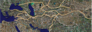
Figure 10. The Location of Tabriz on the Silk Roads in Antiquity from 2nd Century B.C. to 4th Century A.D. (UNESCO, 2009).
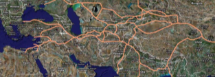
Figure 11. The Location of Tabriz on the Silk Roads from 5th Century A.D. to beginning of 13th Century A.D. (UNESCO, 2009).
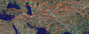
Figure 12. The Location of Tabriz on the Silk Roads from 13th Century A.D. to 16th Century A.D. (UNESCO, 2009).
In the middle of the 9th century the city developed and became famous as “Ebn-e-Maskuye” said Tabriz is a city with numerous gardens and forests and wealthy people (Ebn-e-Maskuye, et all., 1966). Tabriz is among the large cities in the 10th century and “Ibn-e-Hoghel” writes: in this city which has many bazaars, business is thriving and the scarves of Tabriz are unique (Ebne Hooghal, 1966, p.92). “Moghaddasi,” said: Tabriz is stable city and better than Medina and the Jame Mosque is great (Moghaddasi, 1982, p. 561). During “Haroon-al-Rashid Abbasi”, the Abbassid Caliph, a lot of construction and growth happened in Tabriz. But afterward because of several earthquakes happened in Tabriz, the city was destroyed and rebuilt. Tabriz was the capital of Azerbaijan throughout the reign of the Ravadin Dynasty until the attack of “Togrol Bay” (1038 – 1063) (Kasravi, 1956, p. 205). During the reign of “Shamseddin Eldegaz”, (1136 – 1174 A.D.), Tabriz was the capital of Eldegaz dynasty. It has the most prosperous bazaar in Iran and is the famous capital of Azerbaijan in 1178 – 1186 during the reign of “Qizil Arsalan” (Bahrām, 1970, p. 206). After the power of “Qizil Arsalan” it was the permanent capital of Iran and in the time of “Nosrateddin Abu Jeffare Jahan Pahlavan” (1177 – 1191 A.D.), “Atabak Abubakr” (1191 – 1210 A.D.) and his brother “Uzbek” (1210 – 1225 A.D.) it was the capital of the country. The population of Tabriz was close to 100000 at that time (Bonyādof, 1978, p. 188) (See Figures 13 & 14).
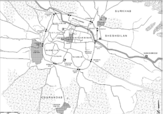
Figure 13. Sketch Map of Tabriz, Pre-Ilkhanid Urban Organization during 12th Century A.D. (Jafarpour Nasser, 2011, p. 4).
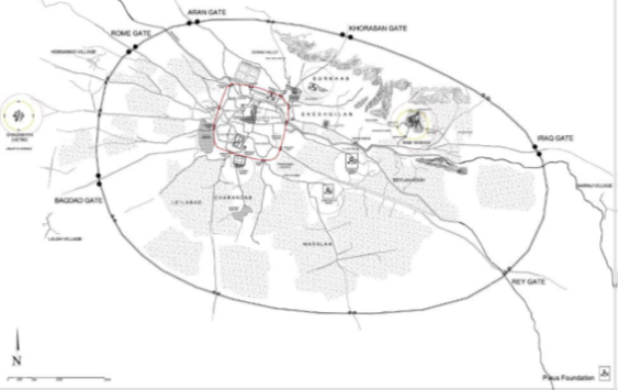
Figure 14. Sketch Map of Tabriz Metropolis, Ghazani wall and Urban Development during Ilkhanid Period (Jafarpour Nasser, 2011, p. 6).
7. 2. 13th Century to 15th Century
Tabriz was one of the most important cities of the world in economic and political issues in this period. In the late 13th and early 14th-century weaving factories of “Rab-e-Rashidi” and “Shamgazan” progressed in Tabriz and fifty weavers came from Antakya and Cyprus to work in Rab-e-Rashidi’s workshops (Hamadāni, 1945, p. 321). Also Paper manufacturing factory was located in Rab-e-Rashidi (See Figures 15 & 16).

Figure 15. Remaining of Rab-e-Rashidi Complex
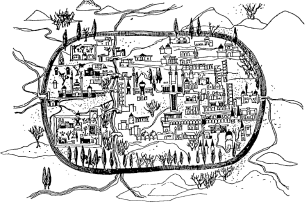
Figure 16. A Drawing of Tabriz by a Turk Traveler, 14th Century A.D. Source: DHUD, 1992 (Azimi, 1995, p. 215).
In 1265, Tabriz was the capital of “Holaku Khan’s” government which ruled from the Amu Darya to Egypt and it was like a climax and turned Tabriz to the central political and economic city of Ilkhanids. Tabriz had a shining economic and social life from the ruling time of “Abaghakhan” to the first years of “Abu Saied’s” ruling (1316 – 1331) which cause the attention of ambassadors from Egypt, India, Europe countries, Byzantium Empires and Pop (Jahn, 1971). The Venetian tourist “Marco Polo” had visited Tabriz from 1294 to 1295 and wrote about its trade in his notes (Tāheri, 1968). “Hamdollah Mostofi” describes the round of barbican around the city which “Ghazan Khan” constructed as 6000 foot with ten main gates (Mostofi, 1957). (See Figures 13 & 14). Also, some caravanserais, baths, and bazaars were built for the convenience of the businessmen who came to Tabriz, they used to take a bath and then enter the city which prevents the entrance of illnesses to Tabriz (Hamadāni, p. 414). In the early 14th century Tabriz roads connected the caravan roads of “Sivas Arzinjan” and “Erzurum” to each other which caused the growth of trade in Tabriz (UNESCO, 2009). Iranian trade roads connected to Tabriz from the south in 14th and 15th century and also the roads of the south and the east started from Tabriz (Estakhri, 1968, p. 161). “Blue Mosque” or “Mozaffarieh building” was built in this period by “Jahanshah Gharagoyunlu” although some say that “Bayim Khatoun”, his wife, and his daughter built it (Tabrizi, 2004, p. 470).
7. 3. 16th Century to 17th Century
In the early 16th century “Ismail” the king chose Tabriz for Safavid dynasty after defeating the last king of “Aghgoyunlu”. This powerful government in Iran was like the “Ottoman” dynasty in Turkey. “Chardin,” said that Tabriz square is larger than Isfahan’s and it is the biggest one he had seen (Chardin, 1956, p. 479). Industry in Tabriz grew faster in the 16th and 17th century, industrial goods of Tabriz sent abroad beyond answering the domestic needs; most of the people in Tabriz worked in business areas (Monshi,2003, p. 303). According to their job they worked in special bazaars and lived in special boroughs. (See Figure 17).
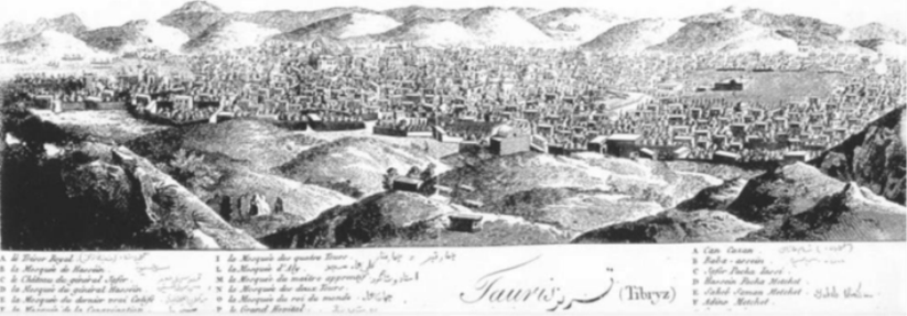
Figure 17. Sketch of Tabriz in Safavid Era; “Chardin Itinerary” (Chardin, 1956, p. 409).
In 1647 there were 200 big and 70 small caravanserais in Tabriz and in 1670 there were 300. Tabriz was the capital of Safavid dynasty for more than half a century and because of its location on the east-west road, played an important role for trading between Russia and Europe; because business with Asia was easier through Russia for western countries (UNESCO, 2009). “Tavernier” considered Tabriz as an important trade bridge between Iran, Turkey, Arabia, Georgia, India, and Russia (Tavernie, 1957, p. 67). In the 16th century the war between Iran and Ottoman made terrible effects on trade of both countries but in 1555 there was a peace treaty between Safavid and Ottomans and during September of 1586 to July of 1603 Tabriz was under occupation of Ottomans and its economic issues were in decline. Even though it was the decline time, Tabriz was still Iran’s industrial and most important trade center at the end of 17th and early 18th century (UNESCO, 2009) (See Figure 18).
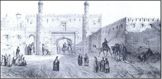
Figure 18. Fortification of Tabriz Reconstructed after Destructive Earthquake in 1780 (By Eugène Flandin) (UNESCO, 2009).
7. 4. 18th Century until 20th Century
After Safavid period “Nader Shah” the king of Afshar defeated the Ottomans and reoccupied Tabriz in 1729; after the Zandiyeh period, “Mohammad Khan Qajar” occupied Tabriz in 1756. “Karimkhan Zand” went there in 1759 and was not successful but after one year he occupied it and “Najafgholi Khan Biglarbeygi” became the ruler of Tabriz and upgraded it. At the last night of 1779 and the first day of 1780 a terrible earthquake ruined Tabriz when it was the start of Qajar dynasty and in short time the city was rebuilt. At the beginning of the 19th century, the center of government in Tabriz transferred from “Sahebabad”, at the north of “Mehranroud” River to the behind of the “Aala” gate or “Baghmisheh” gate at the south of “Mehranroud” River. A commercial center constructed as “Sahib-ul-Amr” square in the “Sahebabad” historical area (See Figures 19 & 20). “Jame Mosque” was restored and returned the centrality of Bazaar of Tabriz. In 1850 England was Iran’s greatest trade partner and Tabriz was the biggest trade bazaar in Iran (UNESCO, 2009).
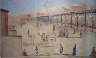
Figure 19. Sketch of Sahebabad Square of Tabriz (UNESCO, 2009).
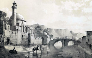
Figure 20. Bridge on the Southern Side of Sahib-ul-Amr Shrine (Eugène Flandin) (UNESCO, 2009).
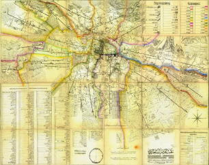
Figure 21. Map of Tabriz Darossaltane Drawn by Sarhang Garajedāghi in 1880 A.D. (UNESCO, 2009).
In 1880 the prince “Abbas Mirza” ordered to prepare the map of Tabriz with urban elements and divisions of the quarters; the name of the houses, mosques, religious places and bazaar are mentioned in this detailed map (UNESCO, 2009) (See Figure 21).
7. 5. Pahlavi Period
On 11th of December, 1925 parliament offered the government of Iran to “Reza” the king and a modern urban system started in Tabriz like the other cities. Because of the entrance of the cars to Iran, wide streets were established; the first street of Tabriz in 1926 was “Pahlavi” which is renamed as “Imam Khomeini” after the revolution. Because of the construction of this street from “Qurd Meydani” to “Qonqa-Bashi” the old street of “Kohne Khiyaban” wasn’t popular anymore and this new street separated “Alishah Mosque” from the bazaar and the core of the city. The second street of Tabriz was built by the mayor of the city, “Mohammad Ali Tarbiat” in 1928 which was from “Nobar borough” towards bazaar. He also built other streets from 1928 to 1931 which ruined the ancient gates of Tabriz. Due to World War II from 1941 to 1946 urban construction stopped in Tabriz like the other cities and since 1950 new streets were built again (UNESCO, 2009).
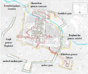
Figure 22. The Location of Historical Gates of Tabriz Old City (UNESCO, 2009).
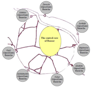
Figure 23. The Situation of Bazaar and Historical Gates of Tabriz Old City (UNESCO, 2009).
Eight gates of Tabriz which connected it to the other cities were: Istanbul gate (to Istanbul and European countries), Davachi or Shotorban gate (to Baku in Azerbaijan), Sorkhab gate, Baghmishe gate (to Ardabil, Rey and East Asia), Khiyaban gate (to Tehran), Nobar gate, Mahadmahin gate and Gajil gate (to Baghdad, Arabia and Africa) (UNESCO, 2009) (See Figures 22 & 23).
8. The design, management, and protection of the urban green spaces show the quality of a city. As the aim of these green spaces is increasing the contact between human and nature, studies proved that the people living in good quality green spaces behave better and crime is low in those areas. They are also important for improving microclimatic conditions, cleaning the weather, filtering the wind, reducing the sound pollution and tourist attraction with their beauty which influences the economics by creating employment. In Tabriz most houses had gardens and there were many famous gardens all over the city in ancient days but after 1920 due to capitalism entrance in Iran, land use was changed from green spaces to residential areas. In 2006 Tabriz had 2.6 million m2 green space and 2353341 m2 parks which indicates a considerable growth compared with previous years. Tabriz had 940,000 m2 parks with suburban function, 282,021 m2 with regional function, 736,518 m2 with local function, 518377 m2 with alley function and 127730 m2 with neighborhood function in 2006. Urban parks have been created in districts 2, 3, 4, and 6 and regional parks are located in districts 1, 2, 3, 5, and 6. In District 8, there is no park with local and regional functions and in District 6 there are no local parks that show the improper distribution of the parks in Tabriz (Abizadeh and Zali, 2013) (See Figures 24, 25, 26 & 27). Urban Green Spaces in Tabriz
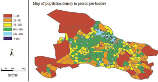
Figure 24. Population Density (Person/ Hectare) in Tabriz (Abizadeh and Zali, 2013).
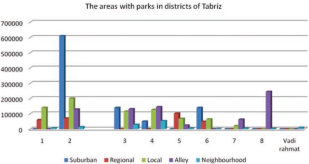
Figure 25. The Areas with Parks in Districts of Tabriz (Abizadeh and Zali, 2013).
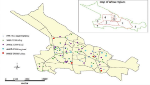
Figure 26. Park Distribution in Different Districts of Tabriz in 2006 (Abizadeh and Zali, 2013).
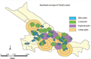
Figure 27. Function Level of Urban Parks in Tabriz (Abizadeh and Zali, 2013).
9. Contemporary Urban Problems in Tabriz
One of the urban systems’ common problems is urban growth and physical expansion without a correct design and program which affects different urban components directly or indirectly. Urban sprawl is a kind of urban growth occurred because of inefficient urban plans, urban economic problems, inconsiderately policies and suddenly decisions for urban development. This phenomenon causes various inconvenient environmental, social and economic problems for the cities. For solving such problems there are some solutions like urban consolidation, sustainable city, compact city, new urbanism and smart growth which are about paying attention to existing urban centers rather than spreading in suburbs. Tabriz is experiencing hasty growth in last decades which is not proportional to its needs and capacity. This process is a continuing issue which empties inner city and expands suburban areas causing physical, economic and social problems. Some of the main problems caused by external expansion are: garden and agricultural lands’ demolition, increasing slums, disconnection of physical tissues, vehicles increase due to the expansion of transportation network, city development on dangerous and unstable lands, degradation of historical identity and vacancy of old tissues. When people immigrate from inner city to suburban area, the old tissue is emptied from original inhabitants and new people coming to the inner city do not have the sense of belonging to this tissue so the identity of tissue is threatened. Another problem is social and economic differences of inhabitants of urban regions, some regions are for low-income people but high-quality regions are for rich people, so this causes crimes, crisis and safety problems which threaten the city. Some physical evolutions in Tabriz indicate the rapid expansion of the city in the periphery area in last decades. The area of Tabriz had tripled, increased from 6440 hectares to 19000 hectares in 1986-2011 while its population had increased from 971482 to 1545491 in the same period so its area growth had been more than its population growth (See Figures 7 & 28). Hasty development of Tabriz caused to the structure of 5838 hectares of Tabriz suburban agricultural and garden lands during 1967 – 1992. In last decades connection networks, various recreation-service centers and commercial projects improve the quality of some parts out of the inner city and also the degradation of qualities of central urban tissue (Kheyroddin, et.al, 2013).
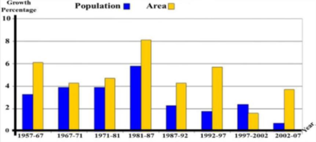
Figure 28. Comparing Population Growth with Area Growth of Tabriz (Kheyroddin, et.al, 2013).
10. Slum Settlements in Tabriz
There are different zones of informal and slum settlements in Tabriz with various ages and origins; the northern zone of the city is more significant among the others because of its history and unique topographic condition. Illegal subdivision and selling of agricultural lands create these kinds of zones but the northern zone of Tabriz has rural bases which have been growing over time and absorbed by the city. The people who live in slums are forced to live in unsafe regions, steep hillsides, flood plains, polluted sites near waste dumps, open drains and sewers or polluting industries; facing high rates of unemployment and addiction. The northern slum area of Tabriz with a population more than 250000 has social, economic, environmental and political problems. The existence of slums in Tabriz is due to rapid urbanization and uneven urban development beyond the steady increase of population. Harsh topography, lack of proper planning for the development, demand for the basic civic services, provision for housing and shelter, water supply, sewage and sanitation, health care services and transportation facilities are the other problems of its inhabitants. Living in this kind of areas creates environmental pollution due to the inhabitants’ unorganized and unsystematic waste and sewage disposal, unplanned houses and unethical habits and values (Moosavi, 2011).
11. Conclusions
During the Islamic period, Tabriz with the centrality of Masjed Jame and bazaar gained stronger economic role. Also, geographical location of Tabriz which is in the center of Azerbaijan and on Iran-Europe transit route is a great opportunity to be the main commercial and economic center in Iran during history. Tabriz has benefited from being a political center as a national capital for some periods but suffered from this centrality by being the main target of several invasions by Turks and Russians between 16th and 19th centuries. Natural disasters like floods and especially earthquakes destroyed Tabriz several times during history which affects city’s growth, but each time the city was rebuilt and survived. With the beginning of modernization, mainly after the 1960s, urbanization changed in Tabriz in terms of population size and internal organization. During last decades the urban population of Tabriz increased dramatically but urban physical growth was much more than it. Thus sprawl approach happened which caused forgetting about the central regions of the city and paying extra attention to the suburban areas and horizontal growth. As a result, the inner city faced degradation of qualitative values because of urban sprawl and paying more attention to suburban development areas.
Acknowledgements
This research did not receive any specific grant from funding agencies in the public, commercial, or not-for-profit sectors.
Conflict of interests
The author declares no conflict of interest.
References
Abizadeh, S., & Zali, N. (2013). Analyzing Urban Green Space Function Emphasizing Green Space Features in District 2 of Tabriz Metropolis in Iran. Anuario do Instituto de Geociencias, 36(1). 119-127. DOI: http://dx.doi.org/10.11137/2013_1_119_127
Azimi, N. (1996). Recent Urban Growth and Change in the Spatial Structure of Iranian Cities: The Case of Tabriz (1966-1991). University of Ottawa (Canada). 64, 70 & 215. http://dx.doi.org/10.20381/ruor-7836
Bonyadof, Z. (1978). Atabakan Azerbaijan Court. Baku. https://courts.gov.az/en/1bakueconomic
Brion, M. (1983). تیمور لنگ فاتح [Tamer Lane the Conqueror]. Translated by Mansouri, zabih-ollah, Tehran: Ketabkhane Mostofi Publication. https://www.ketabrah.ir/
Chandler, T. (1987). Four Thousand Years of Urban Growth: An Historical Census. Lewiston, NY: St. David's University Press. 358. http://pdfilgodor.com/four-thousand-years-of-urban-growth-an-historical-census-categories-to-find-your-favorite-literature-genres.pdf
Chardin, J. (1956)سفرنامه شاردن . [Chardin Itinerary]. Translated by Abbasi. Tehran: Amirkabir Publications, Vol. II. http://www.iranicaonline.org/articles/chardin-sir-john
Chase-Dunn, C., Willard, C., & Willard, A. (1994). Cities in the Central Political/Military Network since CE 1200: Size Hierarchy and Domination. Comparative Civilizations Review, 30(30), 13. 104-132. https://scholarsarchive.byu.edu/ccr/vol30/iss30/13
Ebne Batooteh. (1958). سفرنامه ابن بطوطه [Ebne Batooteh Itinerary]. Translated by Movahhed, A, M. Tehran: Book Translation and Publication House. 254. https://www.goodreads.com/book/show/517598.The_Travels_of_Ibn_Battutah
Ebne Hooghal. (1966) صوره الارض. [The Image of Earth]. Translated by Shoar, J. Tehran: Iran Culture Foundation. http://m-hosseini.ir/islam/articles-5/402.pdf and http://library.sbu.ac.ir/islandora/object/book%3A108590
Ebn-e-Maskuye, Ali-ebne Mohammad-ebne Alasir, Ezzeddin Abol-hassan Beirut. (1966). الکامل فی التاریخ [The Completeness in History]. Vol.8. 68 & 92. https://www.noorlib.ir/View/fa/Book/BookView/Image/14067
Edwards, A. C. (1953). The Persian Carpet. Translated by M. Saba, Tehran: Bita Publications. ISBN-10: 1468313681. ISBN-13: 978-1468313680. https://www.amazon.com/Persian-Carpet-Cecil-Edwards/dp/1468313681
Estakhri, A. I. (1968). مسالک الممالک [Passways of Kingdoms]. Translated by Afshar, I. Tehran: Book Translation and Publication House. http://d-lib.atu.ac.ir/site/catalogue/9619
Etemad-olsaltaneh, M. H. (1878). مرات البلدان ناصری [Time of Naseri Countries]. Tehran, 341 & 362. https://ketabnak.com/
Executive Summary, Tabriz Historical Bazaar Complex. (2009). UNESCO, World Heritage Convention, Iranian Cultural Heritage, Handicrafts, and Tourism Organization. Tehran. https://whc.unesco.org/en/list/1346
Hamadani, R. F. (710). جامع التواریخ [Collector of Histories]. Tehran, Vol. 3. https://hawzah.net/fa/Article/
Hamadani, R.F. (1945). مخابرات رشیدی [Rashidi Intelligence]. Edited by Shafie, M. and Abarqoohi, M. Lahore. https://www.rouydad24.ir/
Hezhabr Nobari, A. (1999–2000). Archive of ICHHTO Archeological Excavations around Blue Mosque. http://ensani.ir
Jafarpour Nasser, S. (2011). مبانی خیرخواهانه مسلمان به عنوان هسته های شهری در توسعه پایدار شهرهای ایلخانی: مطالعه موردی تبریز [Muslim Pious Foundations as Urban Nucleuses during the Sustainable Development of Ilkhanid Cities: a Case Study of Tabriz]. 5th SAS Tech 2011, Khavaran Higher-Education Institute. Mashhad: Iran. https://www.symposia.ir/
Jahn, K. (1971). Doğu ile Batı Arasında Bir Ortaçağ Kültür Merkezi-Tebriz [A Medieval Culture Center Between East and West-Tabriz]. İslam Tetkikleri Dergisi, 4. 29-34. http://dergiler.ankara.edu.tr/dergiler/18/20/43.pdf
Kasravi, A. (1956). شهریاران گمنام [Anonymous Kings]. Tehran, Vol. 2. https://www.goodreads.com/book/show/4955824
Kheyroddin, R., Imani, J., & Forouhar, A. (2013). Consequence Analysis of Spatial Evolution Management in Tabriz Metropolis; “Urban Expanding & Inner City Degradation (1986-2011)”. http://www.asrdlf2013.org/IMG/pdf/C_-_Kheyroddin_-_Consequence_Analysis_of_Spatial_Evolution_in_Tabriz_Metropolis_Urban_expanding_Inner_City_Degradation_1986-2011_.pdf
[The Best Adjustments in Knowing the Regions]. Translated by Monzavi, A. Tehran, Iran, Translators and Compilers Co. Vol. II. http://mtif.org/
Monshi, T. S. (2003).تاریخ عالم آرای عباسی [The History of the World of Abbasi]. Tehran. The Amir Kabir University. http://opac.nlai.ir/opac-prod/search/briefListSearch.do?command=FULL_VIEW&id=657335&pageStatus=1&sortKeyValue1=sortkey_title&sortKeyValue2=sortkey_author
Moosavi, M. (2011). An Introduction to Environmental Challenges of Life in Slum Settlements of Tabriz. In 2011 2nd International Conference on Humanities, Historical and Social Sciences. 106-110. http://www.ipedr.com/vol17/19-CHHSS%202011-H00063.pdf
Morris, J. (2002). تاریخ شکل شهر تا انقلاب صنعتی [History of City’s Formation up to Industrial Revolution]. Translated by Razieh Rezazadeh. V.2. Tehran: Fajr Tose Consulting Engineers Publication (Jahad University of Science & Industry). https://www.adinehbook.com/gp/product/9644544765
Mostofi, H. (1957). نزهة القلوب [The Walk of Hearts]. Edited by Siyaghi, D. Tehran. https://www.noorlib.ir/View/fa/Book/BookView/Image/6783
Sardarinia, S. (2008). تبريز، شهر اولين ها [Tabriz, the City of the Firsts]. Tabriz: Akhtar Publish. http://www.tabnakazarsharghi.ir/
Sotoudeh, M. (1983). حدود العالم [The Limits of the World]. Tehran: Tahouri Publication. https://ketabnak.com/
Tabrizi, H. H. K. (2004). الجنان و جنات الجنان رضات [Gardens of Heavens and Paradises of Heavens]. Sotude Publications, Vol. 1. https://www.gisoom.com/
Taheri, A. (1968). جغرافیایی تاریخی گیلان، مازندران، آذربایجان از نظر جهانگردان [Historical Geography of Gilan, Mazandaran, Azerbaijan In terms of Tourists]. Tehran. 76-77. https://ketabnak.com/
Tapper, R. (1974). Shahsevan in Safavid Persia. Bulletin of the School of Oriental and African Studies, 37(2), 321-354. https://www.jstor.org/stable/pdf/612582.pdf
Tavernie, B. J. (1957). تاورنیه سفرنامه [Taverniye Itinerary]. Translated by Noori, A. Edited by Shirani, H. Isfahan: Taeid Publications. https://ketabnak.com/ 7
UNESCO. (2009). Executive Summary, Tabriz Historical Bazaar Complex. World Heritage Convention, Nomination of Properties for Inclusion on the World Heritage List. Iranian Cultural Heritage, Handicrafts and Tourism Organization. Tehran. http://whc.unesco.org/uploads/nominations/1346.pdf
Vahram, M. (1970). جغرافیای تاریخی و آثار باستانی تبریز [Historical Geography and Ancient Buildings of Tabriz]. Historical Research Magazine, No. 4. https://ketabnak.com/
Woods, J. E., & Tucker, E. (2006). History and Historiography of Post-Mongol Central Asia and the Middle East: Studies in Honor of John E. Woods. Otto Harrassowitz Verlag. 530. https://books.google.com.cy/
Yaqubi. (2015). عجایب الدنیا [Wonders of the World]. Vol. II, 156, 164, 199 & 200. https://www.alarabimag.com/
Zoka, Y. (1980). زمین لرزه های تبریز [The Earthquakes of Tabriz]. Tabriz: Kavian Press. http://www.vojoudi.com/earthquake/cities/tabriz_01.htm
سرشماری جمهوری اسلامی ایران (2006) [Census of the Islamic Republic of Iran]. The Islamic Republic of Iran. Archived from the original on 11/11/2011. https://web.archive.org/web/20110920084534/http://www.amar.org.ir/DesktopModules/FTPManager/upload/upload2360/newjkh/newjkh/23.xls
جغرافیای آذربایجان شرقی (2000) [East Azerbaijan Geography]. Editorial Board. Iranian Ministry of Education. Archived from the original on 10/01/2012. https://ketabnak.com/
نتایج سرشماری ملی (2007) [Results of National Census]. Statistical Center of Iran. Retrieved 11/02/2013. http://azerbaijanstudiescenter.org/ArticleView.aspx?aid=25&gid=
How to Cite this Article:
ASBAGH, N. (2019). A Short Glimpse to the Urban Development of Tabriz during the History. Journal of Contemporary Urban Affairs, 3(2), 73-83. https://doi.org/10.25034/ijcua.2018.4703
This work is licensed under a Creative Commons Attribution - NonCommercial - NoDerivs 4.0.
"CC-BY-NC-ND"