Sansen, M., Martinez, A., & Devillers, P. (2021). Mediterranean Morphologies in Hot Summer Conditions: Learning from France’s “Glorious Thirty” Holiday Housing. Journal of Contemporary Urban Affairs, 5(1), 19-34. https://doi.org/10.25034/ijcua.2021.v5n1-2
 Journal of Contemporary Urban Affairs
2021, Volume 5, Number 1, pages 19– 34
Mediterranean Morphologies in Hot Summer Conditions: Learning from France’s “Glorious Thirty” Holiday Housing
* 1 M.Sc. Marjan Sansen  , 2 Dr. Andrés Martínez , 3 Dr. Philippe Devillers
1,2 and 3 Montpellier National School of Architecture, France
1 E mail: marjan.sansen@montpellier.archi.fr , 2 E mail: andres@andresmartinez.es
3 Email: philippe.devillers@montpellier.archi.fr
ARTICLE INFO:
Received 5 May 2020
Accepted 7 June 2020
Available online 1 July 2020
Keywords:
Morphology;
Mediterranean;
Environmental Assessment;
Additive Architecture;
Holiday Housing.
ABSTRACT 
Climate change and rising temperatures lead to an air-conditioning proliferation in summertime of the Mediterranean regions. This study links urban morphology to the microclimate. It claims that a lesson can be drawn from holiday housing morphologies designed with an additive approach during the “Glorious Thirty” French coastal development (1946-75). It is based on a morphological analysis of four case studies, with on the one hand re-drawing and site visiting, on the other hand, assessment of environmental performance through key parameters: Absolute Rugosity, Compactness Ratio, Building Density, Mineralization, Sky View Factor (SVF) and Height/Width (H/W) Ratio. Compared to literature reference values of a traditional courtyard morphology, the case studies are less compact and with a lower H/W Ratio (higher SVF), but they are less mineral than a historic medieval city centre. This research contributes to the search for semi-collective alternatives (for example additive morphologies) to individual housing in peri-urban areas, with high environmental performance in the summertime.
JOURNAL OF CONTEMPORARY URBAN AFFAIRS (2021), 5(1), 19-34.
https://doi.org/10.25034/ijcua.2021.v5n1-2
www.ijcua.com
Copyright © 2020 Marjan Sansen, Andrés Martínez, Philippe Devillers.
1. Introduction
The “Glorious Thirty” - 1946 to 1975, a depiction of the thirty years of economic boom and the beginning of paid holidays for everyone denotes when mass tourism was born, consequently providing a huge demand for holiday housing on the Mediterranean coast.
It is a period of great excitement and experimentation leading to a “new” architecture occasioned by new technologies such as reinforced concrete, and by a reaction to the Modern Movement, the CIAM (Congrès International d’Architecture Moderne) and its functional city which is typified by standard mass housing and functional urban zoning (Duport, 2015). As a result, the Mediterranean Coast and this new program are used as an experimental laboratory by several avant-garde architects (some affiliated with Team X – the young generation of architects that organized the 10th CIAM congress). They intend to combine rational minimalist architecture (new technologies) with an architecture in due consideration of the site and the environment (sun, wind, nature). They search for an architecture that repeats similar elements to facilitate construction and minimize costs and assemble housing types or units. This brings to the fore the concept of “Additive architecture” which, according to the words of Jørn Utzon (Lukovich, 2018) describes architectural projects based on growth patterns, through the assembly or addition of similar elements.
Several of those avant-garde architects from the “Glorious Thirty” mention the use of vernacular (mountain) villages as references for morphologies. For instance, J. Aubert and A. Lefèvre were inspired by Kabyle mountain villages. G. Candilis specifically quotes Avilcar in Cappadocia, Turkey. Consequently, based on the knowledge of vernacular architecture and personal intuition, additive morphologies are designed specifically for the summer.
Were they pursuing solely a non-monotonous image, by fear of mass production monotony? Or did they study the thermal functioning in the summer heat and apply their findings as design strategies?
From the foregoing, the current study researches if the above morphologies are efficient in summer and how they react under hot summer conditions. This is because there is a nexus between urban morphology, urban microclimate, and energy use (Adolphe, 2001; Taleghani, et al., 2015). The reviewed literature, as a result, treats morphologic and geometric indicators to study this link (Adolphe, 2001). The current research, therefore, uses an integrative approach by simultaneously considering thermal and microclimatic functions, as in the case of Jamei, Rajagopalan, Seyedmahmoudian, and Jamei (2016) and Ratti, Raydan, and Steemers (2003). In this case, the retained indicators are Absolute Rugosity, Compactness Ratio, Building Density, Mineralization, Sky View Factor (SVF), and Height/Width Ratio. Further, many studies are based on what is known as “urban canyons”, or a symmetrical section of a certain length (Oke, 1988). Unlike the current study, they mainly focus on urban city centres.
Although previous studies have been undertaken from a historic and an architectural point of view, their environmental functioning in the summertime is yet to be evaluated (technical and engineering point of view) hence a knowledge gap. The current research, therefore, focuses on this area since individual housing and sprawl are still prevailing in France’s Mediterranean region because up till today, new individual housing is still in demand. The current study broadly contributes to the search for semi-collective alternatives (for example, additive architecture) to individual housing in peri-urban areas. The hypothesis is that these additive residences have positive environmental performance during hot summer conditions, thus providing a certain cooling effect. The specific objectives are to assess the environmental performance of four additive morphologies, to compare them, and finally to relate them with the results of the literature review. As this is done, the “urban canyon” approach, that evokes city centers is applied to peri-urban additive morphologies.
2. Materials and Methods
Four case studies in Mediterranean France have been undertaken, all avant-garde manifestations of a reaction to the Modern Movement: additive architecture, designed with the environment. The case studies were re-drawn using Archicad software, based on cadaster plans, architects’ plans, and aerial pictures. This information was completed with on-site fieldwork. The drawings and 3D models were used for morphology analysis and parameter quantification. Comparison to research reference values allowed environmental assessment. To give a “complete” environmental assessment, there were parameters related to all four climatic aspects: wind, temperature, humidity, and solar radiation (Adolphe, 2001). Although street Orientation and Porosity are also key parameters, they were not examined in this paper since their method of quantification was not satisfactory.
Rugosity describes how the wind is influenced by obstacles. “The higher the rugosity, the slower the main airspeed.” (Adolphe, 2001). Absolute Rugosity is the mean height of the urban canopy, with built and non-built areas (Table 1), and indicates why wind speed reduces owing to morphology. As observed by Oke (1988), though wind disperses heat, too much of it can create a need for shelter. This study assumes that more wind contributes to an increased cooling effect in hot summer conditions.
The Compactness Ratio, on the other hand, reveals how much envelope area is exposed to the outside environment. It is an indicator of potential exchange between the building and the environment (Table 1). The lower the ratio, the less the heat loss (winter) and gain (summer), and the better in hot summer conditions (Ratti et al., 2003).
Mineralization is the ratio of Mineral Area to Total Area (Table 1) (Adolphe, 2001). Vegetation has a cooling effect due to evapo-perspiration (impacting humidity) and shading (protection from solar radiation) (Adolphe, 2001; Jamei et al., 2016). Green and blue areas were therefore traced from the aerial pictures. Literature shows that the shading effect is more important than the evapo-perspiration effect (Ali-Toudert & Mayer, 2007). It is therefore important to consider trees as well as green surfaces. In this regard, all green surfaces were traced. These included: lawns, hedges, trees, private and public green. Generally, the greener the surface (and the lower mineralization), the more cooling in hot summer conditions.
The Sky View Factor (SVF) is a dimensionless parameter that expresses sky visibility in a street. It is the degree to which a wall is exposed to the sky, warming up due to solar radiation during the day, and cooling down at night (Oke, 1988). It ranges between 0 (closed section) and 1 (horizontal flat surface in complete sky contact). SVF can be measured with street view image methods, numerical models, and fisheye photo methods (Miao et al., 2020). This study uses the last. The photographs (obtained on the 13th of March 2020, in the afternoon, for the Ginestou and the Village Grec, and on the 27th-28th of February 2020 for Gaou Bénat and Merlier) were taken in street centres, at 30 cm high.
Through image treatment, the sky was represented in white, buildings and other obstructions, like vegetation, in black. The black and white treatment and the SVF calculation were undertaken using Rayman software. However, some images were pre-treated in Photoshop, since the software interpreted dark skies as walls and white walls as the sky. Analysis of the plans was additionally undertaken to determine typical street widths for each case study. SVF locations were chosen based on the observed widths, and indifferent height situations, that is two buildings of the same height or different heights, a building and a courtyard wall, two courtyard walls, among others. Another criterion was the search for the smallest SVF for every case study, based on intuition and street width. Squares were not considered. Even though this method does not cover the entire residence, it gives an overall image. The lower the SVF, the more protection against summer heat (Jamei et al., 2016; Ratti et al., 2003). As such, the streets remain cool for a longer time during the day. On the contrary, the higher the SVF, the easier the summer heat disappears during the night. For climates with high-temperature swings between day and night, low SVF is considered better for hot summer conditions.
The SVF and the H/W Ratio are inversely related (Oke, 1988). Since the additive ’60s morphologies have very few symmetrical street sections, the H/W Ratio needs some extra attention. The height (H) is defined by the mean height of the elements visible in the SFV photograph (hedge, building, courtyard wall…). The street width (W), on the other hand, is between the defining height elements. Inversely to SVF, a higher H/W is considered better for hot summer conditions (Ali-Toudert & Mayer, 2006; Jamei et al., 2016). Table 1 shows the parameters and their expression used for the environmental assessment.
Table 1. Parameters and their expression used for the environmental assessment.
Ab Total area of the buildings’ footprints (m2)
At Total area of the selected site (m2)
Vb Total volume of the built area (m3)
Sei Envelope Surface of building i (m2): façades plus roofs, without underground and adjacent walls
Au Water and Vegetation Area
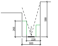
3. Case Study Presentation
Occitanie’s coast, on the Westside, was characterized by mosquito infestations, winds and wine culture. It was a rough 180km strip of sand that thousands of tourists passed every year on their way to Spain or Italy (Figure 1). To transform the region from pass-through to stay-in, the French government initiated its development into a mass tourism destination. A comprehensive undertaking, called Mission Racine, named after the project’s coordinator, Pierre Racine, was consequently established for developing five villages and protected natural green zones between 1963 and 1983. The planning process went hand in hand with extensive sanitation, draining, and infrastructural works.
The Chief Architect, Georges Candilis, designed one of the villages, Leucate-Barcarès and two of the case studies (Village Grec and Ginestou). Although they are private property, they are connected to and part of the urban network which is accessible to everyone. To date, most of the houses are secondary holiday houses, but some of them are inhabited all year round. Leucate has a temperate Mediterranean climate, with warm hot summers (33,8°C in June), temperate winters (-1°C in January), and strong North-West winds during the summer months. Figure 1 presents the location of the case studies.
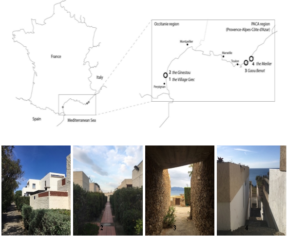
Figure 1. Case study location and photographs.
(1): Village Grec in Leucate; (2): Ginestou in Leucate;
(3): Gaou Benat in Bormes-les-Mimosas; and (4): Merlier in Ramatuelle
The Eastern part of the coast (PACA region) has very different geography with rocky seashores and garrigue vegetation (scrubland). It has been developed mainly through private initiatives. The accent lay less on economic and low budget mass building. Currently, Gaou Benat and Merlier are two private residences, closed communities with a checkpoint at the entrance. Very few people live there all year round and the houses are mostly used as secondary residences (as holiday housing). PACA has a temperate Mediterranean climate as well, with warm hot summers (35°C in May) temperate winters (-2,8°C in December), and strong NNW, SE, and SW winds during the summer months.
All case-studies, apart from the Ginestou, are labeled “Patrimoine du XXème siècle” (label of the Ministry of Culture and Communication for remarkable architecture in France) for their remarkable architectural value. Ginestou received the notion of “exceptional” architecture in a patrimony study of Leucate City.
3.1. Case Study 1: Village Grec, Leucate, 1968
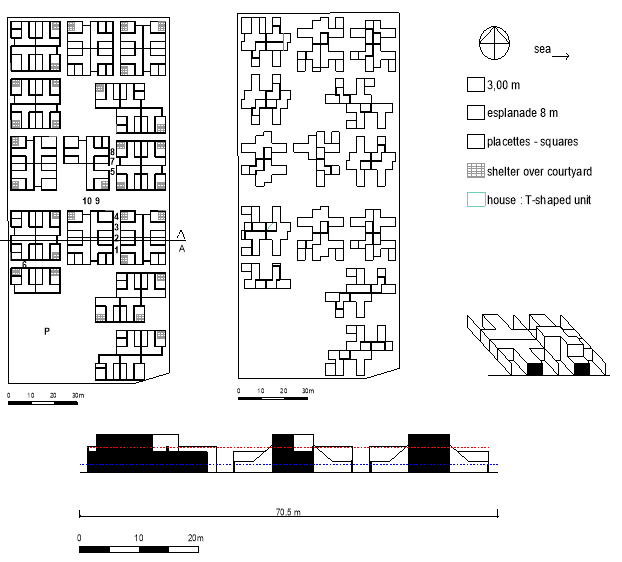
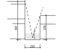
Figure 2. Village Grec. Left: Ground floor with pedestrian street widths and SVF locations;
Middle: first floor
Right: schematic diagram of the assembled “T” units
Bottom: Section A.
Red line: mean building height; Blue line: Absolute Rugosity or mean urban canopy height
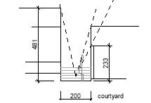
The village’s morphology is created by assembling 53 T-shaped units with two courtyards: a small access court with the entrance door, and a large private courtyard, which is partially sheltered and only accessible from the inside (Figure 2). There is a second, larger, type of “T”, with a first floor. Some small “T”‘s has the first floors as well. All first floors (but one) are offset from the street, to capture the sun on street level. Units are grouped four by four, with a large “esplanade” in the middle. Missing or shifted units are green space, but only very few are accessible and real squares. The central esplanade is also only accessible on a walking path.
While cars stay in the common parking, pedestrians take the 3m wide streets or the 8 m wide “esplanade” (Figure 2). All streets are boarded by hedges from 1 to 3 m high on one or both sides. The overall impression is one of a small-scale village with plenty of green space. Despite the extremely regular road network, an irregular impression comes from different kinds and heights of courtyard walls and shelters, and the randomness of the first floors. It seemingly looks like Candilis’ vernacular village reference. A specificity of this residence is the brick-on-the-side-walls: some walls have bricks with openings turned towards the streets and terraces. They are omnipresent: on every first-floor terrace or courtyard, sometimes near to the ground, sometimes up. They also protect from wind, but let air pass.
In a general way, G. Candilis was sensitive to bioclimatic approaches. This can be seen in his drawings and writings. When he is designing for Iran, for example, ventilation chimneys pop up, and in the tropics, ventilation takes the lead in ideas and drawings. So, in Leucate, he designed for the Mediterranean moderate climate, integrating courtyards, shutters and shelters (for solar protection), hedges and trees (for shade and coolness), small pedestrian passages and accessible rooftop terraces.
3.2. Case Study 2: Ginestou, Leucate, 1963
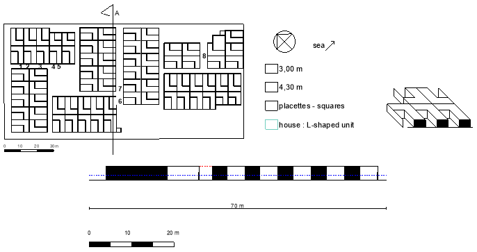
Figure 3. Ginestou. Left: Ground floor plan with pedestrian street widths and SVF locations.
Right: schematic diagram of “L” units’ assembly
Bottom: Section A.
Red line: mean building height; Blue line: Absolute Rugosity or mean urban canopy height
As shown in Figure 3, Ginestou seems to be a simpler version of the Village Grec. As if it was an exercise for the more refined and developed Village Grec (built-in 1968), the plan assembles 73 “L” shaped units with one courtyard, housing the entrance door. The “L”s have a ground floor. They are grouped by 10 or 12 in long blocks (except for two smaller blocks).
Like in Village Grec, cars are parked in the parking lots by the residents, before they head to the village on foot. Pedestrian streets are 3m wide, except for two, which is 4.3m (Figure 3). Like in the Village Grec, hedges board both sides of the streets, although they are less high here. And in the same way, the original design foresaw large green spaces in the courtyards. Courtyard walls are between 1m and 2m high, often with perforated parts to let air pass, and vary from house to house. Besides those, the village has a quite monotonous and repetitive, almost boring, character.
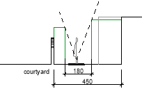
3.3. Case Study 3 : Gaou Bénat in Bormes-les-Mimosas, 1958
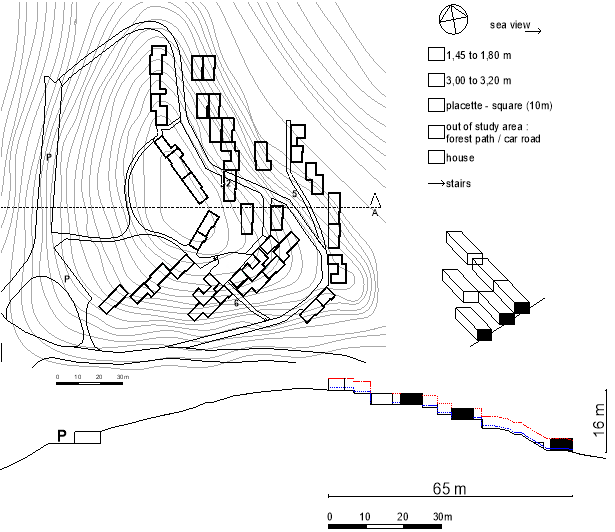
Figure 4. Gaou Bénat: Left: Ground floor plan with pedestrian street widths, slope contour lines, and SVF locations
Right: schematic diagram of the strip assembly of units on a slope
Bottom: Section A.
Red line: mean building height; Blue line: Absolute Rugosity or mean urban canopy height
The main concern for this residential area was to preserve the existing landscape, to create an “architecture of disappearance” as the guardian poetically put it during fieldwork (Figure 4). This was Jean Aubert’s and André Lefèvre-Devaux’s challenge when they were called upon for the development of the Cap Bénat. The question was how to build without being seen, using slope and vegetation. They developed a set of regulations (called the “Cahier des charges”), with sketches and text, based on views, integration into the slope (maximum height 4.5m) and intimacy between houses. Besides, the regulations stipulate climatological aspects, like the positioning of courtyards between the house and the slope for wind and heat protection; or the troglodyte-like covering of roof terraces with earth and vegetation for coolness. The study area (sector G1 or the “Hamlet of the Minotaure”) was designed and built to illustrate those regulations to promote sales. It was the first of six hamlets and the most experimental one. Later on, parcels were sold and constructed individually. Until now, every construction has to correspond to the “Cahier des Charges” and to be approved by a congregation of architects. 36 houses are carefully positioned into the slope (Figure 4). They are oriented East and South-East, towards the Eastern sea view, and only have a ground floor, often stacked at different levels and partially underground, so that views are not hidden by neighbouring units. Houses are juxtaposed, following contour lines, parallel to the slope, and forming a strip. Most of the houses are offset of the road, but enclosure walls, containing terraces and yards, border the streets.
Car parking is situated on the West along the main road that follows the contour line of the slope and that leads cars through the village. Secondary and smaller pedestrian roads or stairs, radiate from here. The village centre is a “placette” or square. This results in an irregular, loose and very green tissue, attached to an irregular street network.
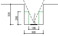
3.4. Case Study 4: Merlier in Ramatuelle, 1958-1965
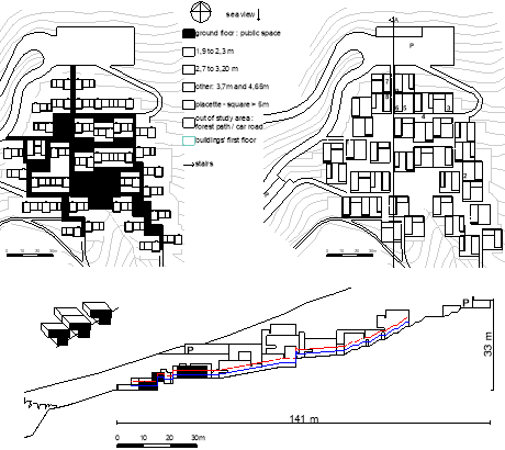
Figure 5. Merlier. Left: ground floor: partial underground units, public pedestrian space in black
Right: first-floor plan: pedestrian street widths and SVF locations
Bottom left: schematic diagram of the grid assembly of units on a slope;
Bottom right: Section A.
Red line: mean building height; Blue line: Absolute Rugosity or mean urban canopy height
Merlier’s challenge was to create holiday housing respectful of the environment that could serve as an example of other vacation developments. These were the main concerns of the private landowner, Simone Volterra. Site visit and observation led to the idea to locate Merlier and four other villages in the hills’ folds and creases so that they would not be visible in the overall landscape. Merlier was the only one built, before the developer’s bankruptcy. A total of 36 houses was established in a landscape fold. The units of 12.5 x 12.5 m are embedded in the slope in a grid-assembly, on different levels and distances (Figure 5).
This system allows the village to cover the natural slopes brilliantly as if it was a forest of houses. The units’ backsides are partially underground. The ground floor covers only part of the square unit, and is oriented parallel to the slope, thus leaving the ground floor space to courtyards. The first floor also only covers part of the square, but is mostly oriented perpendicular to the slope, opening up to the sea view (a view for every unit!), as if the first floor were a covering “croûte”, to use le Corbusier’s words. As a consequence, the ground floor courtyards are partially covered (for shade). The grid positioning leaves plenty of space for “placettes” (squares) in between the units.
There is a car parking space in the North and one in the West, with access to the high part of the village in the East, and the low part of the village in the West. All other streets are pedestrian. Some streets are stairs, like the main pedestrian access from the North: scenic stairs leading down to the village, framing sea views. Streets are rather mineral, despite some green hedges and trees. The ensemble results in an irregular vernacular village-like and mineral tissue blended with an irregular street network and surrounded by trees. Openings between courtyard walls and first-floor cantilevers, between vegetation pots and terraces, between first-floor terrace walls and living room walls give an airy impression, despite the massive and partially underground units.
The design seems to have been made to foster ventilation, also in outdoor areas. Overall, there is specific attention to climatological aspects: south oriented, partially covered courtyards, wooden shutters, the presence of two water basins, vegetation pots on the façades and in the courtyards, green roofs, porous ventilation openings.
4. Results
Table 2. Case study overview (top) and results (bottom)
|
|
Village Grec - 1968
|
Ginestou - 1963
|
Gaou Benat – 1958
|
Merlier 1958
|
|
CASE STUDY OVERVIEW
|
|
Houses
|
53
|
73
|
36
|
35
|
|
Lot area (m2)
|
10 280
|
10 357
|
32 495
|
34 861
|
|
Study area (m2)
|
10 280
|
10 357
|
14 482
|
11 982
|
|
Houses / hectare
|
51.6
|
70.5
|
25.5
|
29.2
|
|
Street Orientation
|
NS & EW
|
NW/SE & NE/SW
|
Streets follow slope: No main direction
|
NS & EW
|
|
Altitude (m)
|
2.0
|
2.5
|
108
|
50
|
|
Distance from the sea (m) –
|
460 (East)
760 to lake (West)
|
730 (East)
350 to lake (West)
|
400 (East)
|
30 (South)
|
|
Dominant wind direction
|
NW
|
NNW, SE & SW
|
|
Slope(%)
|
-
|
-
|
25 – E & SE
|
23 - S
|
|
Materials
|
Prefabricated concrete
|
Prefabricated concrete
|
Local schiste stone, concrete parapet wall, wood shutters, terracotta flooring
|
Bormes stone, Catalan vault, concrete structure and brick filling
|
|
Assembly
|
Small block
|
Long block
|
Strip
|
Grid
|
|
RESULTS
|
|
Absolute rugosity R
|
1.27
|
1.21
|
0.54
|
1.47
|
|
Compactness Ratio Cf
|
0.77
|
0.76
|
0.75
|
0.64
|
|
Building Density (%)
|
33
|
38
|
17
|
48
|
|
Mineralization M (%)
|
70
|
73
|
59
|
70
|
|
|
|
|
|
|
4.1 Absolute Rugosity R (Table 2)
The higher R, the more wind speed is reduced due to the morphology. Merlier has the highest R, meaning wind will be slowed down more. Gaou Benat has the lowest R, so the wind will be less impacted.
4.2 Compactness Ratio Cf (Table 2)
Merlier stands out with the lowest value (0.64), which is rather surprising since it does not look compact at all with its large cantilever overhangs. They are largely exposed to climatological elements; the grid assembly causes different street widths and thus units are only partially aligned, increasing the envelope area even more. The low value can be explained by the slope and the presence of partially underground ground floors and walls. Besides, adjacent houses have common walls on the ground floor. The first floor, on the contrary, has little common walls.
The other three case studies have similar values, for very different reasons. Ginestou has some adjacent walls and no first floor. Village Grec has more adjacent walls on the ground floor, but a very irregular layout on the first floor (with very few adjacent walls). Gaou Benat has few adjacent, but several underground walls, due to regulation proscriptions (courtyards between houses for intimacy, and between slope and houses).
4.3 Building Density - Mineralization M (Table 2)
Gaou Benat stands out for its low densities (17%) and its low mineralization (59%), compared to the case studies in Leucate. All four have different kinds of green. Gaou Benat is a natural green site, with some houses and streets carefully integrated and a low Building Density. Green is omnipresent and intermingled with the buildings. Village Grec and Ginestou are the opposite: a mineral site, with green carefully integrated. The result is small-scale green (like lace), due to a high Building Density and small units. All streets are boarded with hedges and shifted or missing units are green spaces. Ginestou has a high number of green courtyards (private green). Merlier, at last, combines both: natural green surroundings, and small-scale green within the grid (planters on all terraces and courtyards are part of the initial design).
Although the photographic method does not cover the entire residence, it clearly shows different tendencies or characters for every residence.
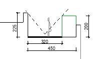
Table 3. A selection of SVF, in increasing order. The fish-eye photographs are in the direction of the street (North up). The dotted line on the sections shows the visible element on the fisheye photograph, which is used for H/W. The first value of the covered passage is not considered for further interpretation.
|
Location and street width
|
Section
|
SVF (from low to high)
|
H/W
|
|
Gaou Benat
2.
3,20 m
A covered passage under house
|

|
  0,01 0,01
|
0.66
|
|
Merlier
2.
2,00 m
Stairs between two buildings
|
|
 
0,10
|
1.94
|
|
Merlier
7.
2,30 m
Stairs between two buildings
|
|
 
0,15
|
2.08
|
|
Village Grec
7.
4,50 m
Between an access courtyard and an offset unit
|
|
 
0,29
|
1.53
|
|
Village grec
6.
3,00 m
Between a unit with a terrace on the first floor – a unit with a first floor
|
|
 
0,39
|
1.85
|
|
Ginestou
1.
3,00 m
Between two units of same height
|
|
  
|
1.29
|
|
Gaou benat
1.
4,50 m
Between hedge and terrace wall - Main car and pedestrian street
|
|
  
|
0.66
|
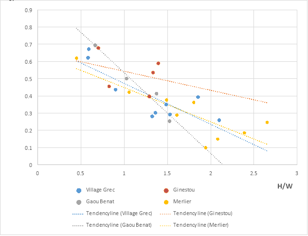
Figure 6. SVF to H/W for the four case studies with a tendency line per case study. Gaou Benat’s covered passage is not considered in the graph, since it is a very small passage and has a huge impact on the tendency line.
Gaou Benat stands out because it has the lowest (0.01) and highest SVF values (0.69) (Table 3). The lowest is a punctual passage under a dwelling. There are two of those in the village. The highest SVF is on the main road for pedestrians and cars. Most dwellings keep a distance from roads to protect intimacy so that most of the roads are boarded by yard walls or courtyard walls, which are lower than building façades. Also, the roads are parallel to the slope, so there’s always a house higher, and another one lower than the road. This all adds up to a high SVF. The small SVF of Gaou Benat is on punctual spots, like two covered passages, a stair leading to the central square, or part of a secondary road. The main road and central square have a high SVF.
Merlier stands out with the lowest SVF after Gaou Benat’s passage (0.1 and 0.15) (Table 3) and the highest H/W (2.65 and 2.39) (Figure 6), due to the presence of a second floor (and third floor for some units), and to vegetation (public and private), both are on the stairs. The grid morphology has several more stairs with similar H/W. Thus, several areas in the residence are well protected against summer heat.
Village Grec does not stand out but has a similar tendency line as the Merlier (Figure 6). Offset first floors do not influence SVF, high hedges and trees do. This is because it does not have passages with a very low SVF, although finding “the smallest passage of the residence” was part of the fieldwork. The lowest SVF is 0.4 (Table 3). All passages have a minimum width of 3m, there’s no first floor and hedges are lower than in the Village Grec. Courtyard walls are between 1m and 2m, which is lower than a unit wall. Besides, Candilis’ search for intimacy and non-monotony led to pedestrian streets where courtyards and buildings take turns, meaning there are a few passages with high H/W Ratio. Ginestou has the highest SVF values, the lowest H/W Ratios (Table 3) and the highest tendency line (Figure 6).
All low SVF measures are low thanks to vegetation (except for Gaou Benat’s covered passage). Building height is not decisive: a section with a higher building and a high H/W of 1.85 (Village Grec number 6 – Table 3) can have a higher SVF (0.39) than a section with a low courtyard wall and H/W 1.53 (Village Grec number 7 – Table 3): SVF 0.29, because of the hedges. Trees also have a large impact on SVF. The vegetation might be part of the residence’s public areas or part of the private courtyards. The smallest SVF of the Merlier (0,10) illustrates the latter with private vegetation from the neighbouring courtyard covering the passage.
4.5. Comparaison (Figure 7)
It is not possible to point out one residence and label it the “best environmental performance” in hot summer conditions since the link between morphology and microclimate is too complex. It is possible though to compare their parameters and to indicate the residences that are more likeable to have a positive effect in hot summer conditions concerning these parameters (the lower the values, the better, except for the H/W Ratio).
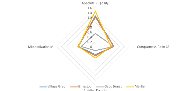
Figure 7. Case study comparison. The residences with the most positive effect in hot summer conditions are the ones with the lower values. Gaou Benat stands out because the wind has fewer obstructions (low Absolute Rugosity) and it’s greener (low mineralization). Merlier stands out because it has the lowest Compactness Ratio.
Gaou Benat stands out because the wind has fewer obstructions and it’s greener (low mineralization). Merlier stands out because it has the lowest Compactness Ratio, the lowest SVF and the highest H/W Ratio.
5. Discussions and conclusions
The obtained Absolute Rugosity R values (0.54 to 1.47), are lower than the reference value of the historical city centre of Toulouse: 7.1 (Adolphe, 2001). This makes sense since historical centres have several floors. They can be compared though to the reference value of 0.8 for a suburban area of Toulouse, with a majority of individual houses (Adolphe, 2001).
This value alone is not very representative of the subtle design strategies that have been implemented in the residences to favour air movement: brick-on-the-side-walls and courtyard walls with openings for air movement, balconies with offset walls to let air pass… Further study will add other values, like porosity, roughness length, street orientation and main wind directions.
The obtained Compactness Ratio Cf values (0.64 to 0.77) are higher than reference values of 0.584 for a traditional courtyard morphology (like central Marrakech with 9m high houses) (Ratti et al., 2003). They are also higher than 0.404 for more modern urban morphologies (3 floors, 9m high, pedestrian streets without cars).
If we would imagine an individual house with the same volume as a Merlier unit, with two floors and a rectangular floor plan of 8 x 10m, the compacity ratio would be 0.61. Again, the obtained values are higher. For the same volume as the Ginestou, with a single rectangular floor of 6 x 9m, the compacity ratio would be 0.87. This individual house with one floor would be less compact than the additive grouped housing. So, the additive case studies are not compact at all.
High Compactness Ratios mean a large envelope surface in direct contact with environmental conditions. Low compacity means less heat loss in wintertime and less heat gain in the summertime. So, in general, low compacity is favoured. This was also the hypothesis used for this study. But is low compacity always better? Ratti et al. (2003) claim that higher compacity, in warm climates, can also mean a higher wall mass, that can function as a heat sink. This means that, when combined with inert walls and high diurnal temperature swings (large temperature difference between day and night), high compacity can have a positive effect, according to this research. Further research will point out whether there are other conditions where a high Compactness Ratio has positive effects.
The obtained H/W values are higher than Oke’s reference values for a mid-latitude city with 45° latitude, like for example Avignon or Lyon (Oke, 1988). Leucate is at 42,85°. He mentions theoretical values 0.4 as a lower limit, to allow solar access and 0.60 - 0.65 as a high limit for wind protection and shade. The measured case study values go from 0.66 – 2.08, which is higher. This means the additive residences are more adapted to hot summer conditions than theoretical mid-latitude morphologies.
The measured SVF values (0.10 to 0.69) are higher than Ratti’s reference values of 0.13 for a traditional courtyard morphology (like central Marrakech with houses of 9m high) (Ratti et al., 2003), except for one measure in Merlier. They’re also higher than more modern urban morphologies (3 floors, 9m high, pedestrian streets without cars): 0.23, except for three measures in the Merlier. This means that the street proportions of these additive residences are more open to the sky than the traditional vernacular morphology of Marrakech. This Moroccan city centre is known for its narrow streets, which are well shaded during the day, and cool slowly at night when temperatures drop. When we make abstraction of vegetation, the additive residences’ streets are thus less adapted to hot summer conditions than Marrakech. We should keep in mind, though, that the architects’ reference was vernacular villages and not vernacular urban city centres.
Compared to Adolphe’s reference values of 95% Mineralization (Adolphe, 2001) for Toulouse’s medieval city centre, the measured values are 22-36% less mineralized, or the additive morphologies are greener than historical city centres.
The interpretation of results depends on the reference values. This study compared obtained values to reference values of urban canyons, that have a symmetrical section for a certain length. Many previous studies narrowly focus on (often vernacular) urban centres. Consequently, the current study compared the results to available reference values of urban centers that have a certain thermal functioning in high temperatures. Further research will need to be undertaken to explore whether there are other thermal ways of functioning, for example for village centres or green palmeraies with sparse housing.
This research focused on an environmental assessment of additive holiday housing from the “Glorious Thirty” in France, with an integrative approach. Four neighbourhoods were analyzed and compared to each other, as well as to the results of the literature review. Although the residences have been studied before, from a historic and architectural point of view, their environmental functioning in summertime has not yet been evaluated. This research, therefore, contributes to the search for semi-collective alternatives of individual housing in peri-urban areas.
Acknowledgement
The authors wish to acknowledge the financial funding provided by FEDER (Fond Européen de Développement Régional) – Région Occitanie for the research project “OEHM - Optimisation Energétique de l’Habitat Méditerranéen”.
Conflict of interests
The authors declare no conflict of interest.
References
Adolphe, L. (2001). A Simplified Model of Urban Morphology: Application to an Analysis of the Environmental Performance of Cities. Environment and Planning B: Planning and Design, 28(2), 183-200. https://doi.org/10.1068/b2631
Ali-Toudert, F., & Mayer, H. (2006). Numerical study on the effects of aspect ratio and orientation of an urban street canyon on outdoor thermal comfort in hot and dry climate. Building and Environment, 41(2), 94-108. https://doi.org/10.1016/j.buildenv.2005.01.013
Ali-Toudert, F., & Mayer, H. (2007). Effects of asymmetry, galleries, overhanging façades and vegetation on thermal comfort in urban street canyons. Solar Energy, 81(6), 742-754. https://doi.org/10.1016/j.solener.2006.10.007
Duport, L. J. (2015). Georges Candilis (1913-1995) architecte pour le plus grand nombre [Le Corbusier, 50 years later], LC2015 - Le Corbusier. http://doi.org/10.4995/LC2015.2015.664
Jamei, E., Rajagopalan, P., Seyedmahmoudian, M., & Jamei, Y. (2016). Review on the impact of urban geometry and pedestrian level greening on outdoor thermal comfort. Renewable and Sustainable Energy Reviews, 54, 1002-1017. https://doi.org/10.1016/j.rser.2015.10.104
Lukovich, T. (2018). UTZON 100. YBL Journal of Built Environment, 6(1), 130-150. https://doi.org/10.2478/jbe-2018-0009
Miao, C., Yu, S., Hu, Y., Zhang, H., He, X., & Chen, W. (2020). Review of methods used to estimate the sky view factor in urban street canyons. Building and Environment, 168, 106497. https://doi.org/10.1016/j.buildenv.2019.106497
Oke, T. R. (1988). Street design and urban canopy layer climate. Energy and Buildings, 11(1), 103-113. https://doi.org/10.1016/0378-7788(88)90026-6
Ratti, C., Raydan, D., & Steemers, K. (2003). Building form and environmental performance: archetypes, analysis and an arid climate. Energy and Buildings, 35(1), 49-59. https://doi.org/10.1016/S0378-7788(02)00079-8
Tadi, M., Zadeh, M., Biraghi, C., & Brioschi, L. (2017). Urban Porosity. A morphological Key Category for the optimization of the CAS's environmental and energy performance. GSTF Journal of Engineering Technology, 4(3). https://doi.org/10.5176/2301-394X_ACE17.68
Taleghani, M., Kleerekoper, L., Tenpierik, M., & van den Dobbelsteen, A. (2015). Outdoor thermal comfort within five different urban forms in the Netherlands. Building and Environment, 83, 65-78. https://doi.org/10.1016/j.buildenv.2014.03.014

Sansen, M., Martinez, A., & Devillers, P. (2021). Mediterranean Morphologies in Hot Summer Conditions: Learning from France’s “Glorious Thirty” Holiday Housing. Journal of Contemporary Urban Affairs, 5(1), 19-34. https://doi.org/10.25034/ijcua.2021.v5n1-2
*Corresponding Author:
Montpellier National School of Architecture, France Email address: marjan.sansen@montpellier.archi.fr
This article is an open access
article distributed under the terms and conditions of the Creative Commons Attribution (CC BY) license

This article is published with open access at www.ijcua.com