D:\My Journal\Logo\kam logo.JPG


Journal of Contemporary Urban Affairs

         2021, Volume 5, Number 1, pages 85– 100

Enhancing Security in Affordable Housing: The Case of Prince Fawaz Project

Professor Dr. Maged Attia Image result for research orcid

Department of Architecture, Faculty of Architecture and Planning, King Abdulaziz University, Jeddah, KSA

Email: mattia@kau.edu.sa


ARTICLE INFO:


Article History:

Received 9 March 2021

Accepted 15 May 2021

Available online 30 May 2021


Keywords:

Environmental crime;

Enhancing security;

Crime rates;

Prince Fawaz project;

Saudi Arabia.

ABSTRACT                                                                                                                                                                                                                                                                                                                                                                                         


The present study argues that the urban form of affordable housing projects affects safety and security. The study examines the level of safety and security in the Prince Fawaz project proposing recommendations that enhance it. Theories and approaches concerned with the environmental crime are initially reviewed. Then, urban and architectural features as well as crime rates and patterns are documented. Also, trace and behaviour observations are carried out. The observations monitored urban features and behaviours associated with crime or fear of crime. Residents’ perception for security and fear of crime is extracted through a questionnaire. A Space Syntax is processed and linked with the questionnaire and observation outputs. Observations demonstrate a semblance of fear of crime which is supported by records of car and home theft. Although the questionnaire reflects a suitable level of security, it points to peripheral spaces and areas around mosques and shops as the less secure. However, enhancing security in the Prince Fawaz project requires urban interventions including controlling access to peripheral spaces, reviving areas detected to be unsafe, repositioning elements causing visual obstacles and enhancing appearance by vegetation and sustainable maintenance. Besides, reformulating the movement network so that an appropriate integration between residents and strangers is achieved. On the conceptual level, the study proves that none of the theories of environmental crime can act as a comprehensive approach; but each can partly work.


This article is an open access

article distributed under the terms and conditions of the Creative Commons Attribution (CC BY) license

C:\Users\Hourakhsh\Desktop\CC_By_2020_licnece1.jpg

This article is published with open access at www.ijcua.com

JOURNAL OF CONTEMPORARY URBAN AFFAIRS (2021), 5(1), 85-100.

https://doi.org/10.25034/ijcua.2021.v5n1-8

www.ijcua.com

Copyright © 2021 Professor Dr. Maged Attia.


1.       Introduction

With the economic prosperity of the mid-seventies, the Saudi government began to build many housing projects to meet the growing population and the immigration from villages to cities (Al Hazza', 2001). Traditional society is in general deeply religious, conservative, and family-oriented. Whereas in the urban lifestyle, fathers used to absent outside the home for long hours, women went to work relying on foreign nannies and maids in raising children, and sons acquired more freedom. The recruitment of labour from different nationalities led to noticeable social changes. Social networks have made the new generations more vulnerable to changes in beliefs, behaviours, customs and traditions, and religious values. The socio-economic changes caused pressures that led to a rise in crime rates and the emergence of new types of crime (Abdullah Eben Saleh, 1999; Al Beshr, 2000).

The crime rate in Saudi Arabia is generally low compared with other countries. Though, in 2005, the number was significantly raised to about 90000 crimes, with a rate of 392 crimes per 100000 people. By the year 2006, the number of criminal offences dropped to 88609 with a rate of 354 crimes per 100000 people (Abu Shama, 2007). During the year 2014, the number of crimes reached 96000 but with a rate of 311 crimes per 100000 people (El-Torky, 2015). The number of crimes in 2016 reached 149781 with a rate of 464.46 crimes per 100000 people. This number dropped by 4.5 per cent in 2017 (SABQ, 2017). During the last three years, the Saudi government is adopting serious reforms in its economic policy causing a huge number of job’s lay off of foreign labour and accordingly dramatic socio-economic changes took place. Without specific figures, OSAC Crime and Safety Reports of 2019 and 2020 indicate that crime in Saudi Arabia has increased but remains at levels far below most major metropolitan areas (OSAC, 2019, 2020).

It is worth mentioning that Saudi Arabia has two types of police forces namely general and religious. The general police are responsible for national security and crime investigation. While, religious police is in charge of enforcing religious customs of "Sharia" (Like segregation of sexes, the prohibition of alcohol, men attending prayer, suppression of non-Muslim displays, and the modesty of women.) (Pietenpol et al., 2018).

Crime in residential areas is a vital issue because it affects the work of police departments, real estate agents, and residents. Crime, or fear of crime, has a direct reflection on outdoor activities, psychological status, communal relationships as well as real estate value (Marques et al., 2018). Ghani (2017) argues that the frequent occurrences of crimes in urban area instil fear and accordingly reduce economic opportunities, safe living and quality of life. Crime reduction can be an effective tool for investment in the housing sector (Lacoe et al., 2018); this is crucial for affordable housing.

Literature does not establish that urbanization causes crime, but it is linked with a crime because it harbours many people which some of them may tend to crime (Soh, 2012). Yet, in many instances, the urban configuration of the residential area contributes to making a settlement an attractive area for crime (Lorenc et al., 2012). The relationship between crime and urbanism attracted the attention of architects, planners, sociologists, criminologist and policemen. There are some theories, approaches and tools that aimed at promoting security and reducing opportunities for crime and risk in the built environment. Theories include the Defensible Space, Broken Window and Crime Prevention Through Environmental Design (CPTED) (Adel et al., 2016). New Urbanism is an urban design approach that, among other objectives, advocates safety from crime (CNU, 2001). Alongside other applications, Space Syntax seeks to find explanations for the places in which crime incidents occur (Hillier & Sahbaz, 2008).

The problem of understanding the impact of urban design on crime lies in the complexity of measuring this relationship. Although many attempts have been made worldwide, it is receiving inadequate interest in Saudi Arabia. Therefore, the present paper is an attempt in this direction.


2.       Material and Methods

The research reviews theories and approaches concerned with the relationship between urban design and security, crime and fear of crime. In the case study, many techniques are utilized. First, data related to Prince Fawaz affordable housing project is gathered including rates and patterns of crime over the last three years. Second, a trace observation is tackled to monitor features associated with crime or fear of crime such as fences, protection iron and visual obstacles. Third, behaviour observation detects activities that might have a relationship with crime. Fourth, a questionnaire is conducted to explore levels of security in different spaces, places and times in which residents feel more vulnerable to crime, previous experience with crime, and prevailing types of crime. A sample of 360 questionnaires was distributed covering about 27% of the project’ units. The sample realizes a confidence level of 95%. The questionnaire form includes several closed-ended questions with bilateral answers; while, others are formulated in a Likert-type scale. At the end of the questionnaire, residents are asked about their suggestions for enhancing security. The urban pattern of the Prince Fawaz project then processed with Space Syntax. With Depthmap, many measurements are derived, and data obtained from observation and questionnaire are correlated. An interpretation of concluded results accompanied by recommendations for enhancing security and reducing crime in the Prince Fawaz project are then discussed (Fig. 1).


Figure 1. Research Methodology.


3.       Theory

The relation between crime and the built environment has been the interest of environmental criminology (Anna Alvazzi del Frate, 1993; Brown & Altman, 1983; Cozens, 2002; Yazdanfar & Nazari, 2015). It is based on the idea that criminals take geographic factors into account when deciding on crimes (Bartol & M., 2006). Many theories and applications were built on environmental criminology such as rational choice, routine activity and crime pattern (Malleson & Birkin, 2012; Shon & Barton-Bellessa, 2015; Wilcox, 2015). However, several attempts have been made to derive criteria that can enhance security and reduce crime in housing communities as discussed below.

Defensible Space: Oscar Newman's ‘Defensible Space’, introduced in 1972, was based on four design elements including territoriality, natural surveillance, image and milieu (Zen & Mohamad, 2014). The theory advocates the consensus between a homogeneous group of inhabitants in a specific urban context which includes a hierarchical system of open spaces, with the maximization of private and semi-private spaces on the account of public and semi-public ones. Accordingly, access to an area should be limited to legal users whereas strangers are believed to be the source of danger. Defensible Space adopts the separation of residents from strangers, whether by physical or symbolic means (Newman, 1972). However, if Defensible Space could succeed on a limited scale, it will be difficult to be replicated at the city level which, according to Hillier (2004), will transfer into segregated islands leading to encouraging criminal activities and increasing the fear of crime. Empirical studies did not support Defensible Space too (Cozens et al., 2001).

Crime Prevention Through Environmental Design (CPTED): CPTED is affected by Defensible Space in terms that the safe community must enjoy a sort of control on danger, personal threat and crime (Mohit & Hannan, 2012). CPTED aims to make the physical context safe for normal users but make it uneasy for abnormal users to engage in inappropriate behaviour. CPTED relies on strategies including territoriality, surveillance, consolidated activities, controlled accessibility, sustainable maintenance and good management, and target hardening within geographical juxtaposition (Ha et al., 2015; Piroozfar et al., 2019). Natural surveillance in live spaces will thus discourage crime. Meanwhile, assigning clear functions for spaces accompanied by sustainable maintenance and management is expected to leave a limited chance for crime. So, CPTED is embodied in the Three-D Approach which includes “Designation” concerned with the activities assigned for spaces, “Definition” concerned with the physical boundaries of spaces, and “Design” concerned with the practice of desired uses in a safe manner (Marvi & Behzadfar, 2015; Sakip & Abdullah, 2012). Like Defensible Space, empirical studies prove that CPTED outputs are not confirmed (Elbadawi, 1991; Hardy, 1997; Robinson, 1997; Serpas, 1998).

Broken Window: Broken Window theory believed that serious crimes occurred as a result of a series of minor crimes. The theory links crime with disorder and argues that if the disorder was eliminated then serious crime would not occur (Austin et al., 2002). Thus, a well-maintained environment could reduce and prevent criminal activities. This link has been shown to be often non-existent (Harcourt, 2009). The theory has been criticized for being only a short-term solution, not a robust theory (Taylor, 2001; Thacher, 2004). However, the theory reinforced the principles of natural surveillance and territoriality.

New Urbanism: The approach tried to avoid the criticism of urban design for its lack of humanity, responsiveness, sensitivity as well as lack of safety from crime. Unlike Defensible Space, New Urbanism adopts expansion in public spaces to encourage interaction between users and strengthen the sense of affiliation, the mixture of uses to support the vitality and increase the presence of people in streets, encouraging walkability by utilizing grid pattern of streets, allocating buildings adjacent to streets to enhance natural surveillance, and finally increasing densities (Elshater, 2012). However, Foster et al. (2016) argue that New Urbanism may deliver social and wellbeing benefits but its impact on creating safe space is still subjective. Evidence from criminology links the main features of New Urbanism with increased levels of crime. For instance, the non-residential land uses which constitute destinations to walk to have been associated with an elevation in property crime levels. Likewise, street connectivity is a fundamental aspect in new urbanism to provide direct and varied walking routes for residents; yet, streets are also easily navigated by offenders with more options of escape routes (McCord et al., 2007).

Space Syntax: Space Syntax as a configurational analysis method was established by Hiller in 1984 based on the research of Hiller and Hanson on the concept of "Social logic of space" (Hillier & Sahbaz, 2005). The technique is applied to examine how the physical or visual accessibility of a spatial system affects the social behaviour of users; eliminating crime is one of the main concerns. In a spatial system, the value of accessibility of a street segment from all-around ones is identified by two measures which are integration and connectivity. In residential areas, studies demonstrate that streets that enjoy a higher integration value, and hence higher accessibility, enjoy more security levels than segregated ones (Ballintyne et al., 2000; Elgarmadiand & Özer, 2018). The presence and social interaction within a space prevent criminals from committing a crime because they could be easily caught then. But it does not seem that the relationship between urbanism and crime is identified by accessibility only. Many studies demonstrate conflicting results according to variations in income level, density and education (Nubani & Wineman, 2005). Sonia Hirt and Zahm (2012) argue that as long as the city has inconsistent types of open spaces, movements and activities, crime rates will unexpectedly vary from one area to another. This is confirmed by Hagan and Daigle (2018) who emphasize the fact that there is no absolute right or wrong in criminology. Table (1) summarizes the above discussion.


Table 1. Theories of environmental criminology, corresponding implications and impacts.

Theory/Approach

Main concept/principles

Implication to urban design

Impact in practice

Defensible Space

Territoriality, geographical juxtaposition, natural surveillance, image and milieu

-           Minimized common areas

-           Maximized private ownership

-           Boundary definition

-           Minimized permeability

-           Results are not confirmed

CPTED

Territoriality, natural surveillance, access control, activity support, image management, geographical juxtaposition

-           Mixed land use

-           Border definition of controlled space

-           Clearly marked gathering areas

-           Reduce use conflicts with natural barriers

-           Overcome distant and isolation

-           Crime levels dropped, but

-           Encouraging burglaries crime

-           Reduction of crime in the town centres not in housing areas

Broken Window

Well-maintained environment,

natural surveillance and territoriality

-           Regular maintenance

-           Could reduce and prevent criminal activities

-           Short-term and partial

-           Failed to consider collective efficacy

New Urbanism

Vitality and sense of community, walkability and minimum car dependence, and natural surveillance

-           Expansion in public spaces

-           Mixed land use

-           Grid pattern of streets

-           Buildings adjacent to streets

-           Compact development

-           Increasing densities

-           Linked with increased levels of crime

-           Still subjective


Space Syntax

The increased accessibility and social interactions (reflected in Integration and Connectivity measures)

-           Enhancing pedestrians and vehicles movement

-           Results widely varies depending on income level, density and education


Vegetation is an integrated component of urbanism. Like the built environment, the impact of vegetation on crime is still questionable. From one side, vegetation is believed to encourage crime as it can help to conceal criminals while they plan and execute crimes and then disappear (Nasar et al., 1993). Also, being visual obstacles, vegetation limit visibility and hence promote fear (Nasar & Jones, 1997). Donovan and Prestemon (2010) indicate that smaller trees that obstruct visibility were associated with increased crime in residential areas. On the other side, the latest research argues that well-maintained vegetation enhances reducing rates in certain types of crime. Studies attribute the reduction in crime rates to increased surveillance in vegetated spaces and the delightful mode resulting from the landscape. For instance, rich vegetation is considerably associated with lower rates of assault, robbery, and burglary, but not theft crimes (Wolfe & Mennis, 2012). Maas et al. (2009) argue that, in residential areas, vegetation could effectively decrease fear of crime, enhance the sense of safety and reduce reported crime. In large Neighbourhoods, vegetation contributed to reducing violence and property crime (Kuo & Sullivan, 2001). Moreover, Donovan and Prestemon (2010) found that large private trees and street trees enhanced lower crime rates. Finally, the greening of vacant plots could reduce gun assaults and vandalism (Branas et al., 2011).


4.       Case Study

Prince Fawaz project is located about 10 Km from the centre of Jeddah on Jeddah-Mecca highway which intersects with Prince Fawaz road splitting the project into four distinctive zones: A (602 units), B (200 units), C (314 units) and D (202 units) (Fig. 2). Each zone is divided into blocks including some two floor detached dwellings that are dedicated to mid-income Saudi families (Fig. 3). The project enjoys many public services such as mosques, open spaces, shops, a sports centre and primary, middle and secondary schools.


Figure 2. The layout of Prince Fawaz project, Jeddah (Source: Google Earth, edited by the author).


4 a.jpg

Figure 3. A typical dwelling of the project (Source: The author).


4.1. Crime Rates and Patterns in Prince Fawaz Project

Rates and types of crime in the Prince Fawaz project during the last three years (2017-2019) are summarized in Table (2). Unfortunately, the information does not include the location of the crimes. The table indicates that crimes in the project are classified into four types: money molesters, self-molesters, moral and juveniles.

Data in the table (2) show that, during the year 2017, the number of money molesters’ crimes reaches figure 33 i.e., 52% of the total number of crimes. Car theft, with the number of 16 crimes, is the highest on the list representing 25.3% of the total crimes. Moral crimes, including sexual offences and drinking alcohol, reach 17 crimes, i.e., 26.9% of the number of crimes which makes them come second. Drinking alcohol topped the list of moral crimes with the number 12 representing 19% of the total crimes. The number of self-molester crimes reaches 12 i.e., 19% of the total crimes.

During the year 2018, the number of reported crimes has doubled reaching 116 crimes. Again, money molesters’ crimes come in the first place with a number of 63 criminal offences, i.e., 54% of the total number of reported crimes. Car theft topped the list followed by home theft with the numbers of 27 and 13 crimes respectively. Moral crimes reach 32 crimes, i.e., 27.5% of the total number of crimes, mostly like the previous year. Although the number of self-molester crimes rose to 17, its percentage of the total number fell to 15% of the total crimes.

In the year 2019, the number of crimes in the project declined to reach 77 crimes, i.e., 66% of the number of 2018, and slightly exceed the record of 2017. Still, money crimes, which amount to 45, represent about 58% of the total number of crimes. Car theft topped the list followed by home theft with 22 and 10 crimes respectively. Moral crimes reach the number of 20 representing 26% of the total crimes. While self-molester crimes dropped to 8 representing about 10% of the total crimes.

The above figures indicate that although the total number of crimes varies among the three years, the number of money molesters’ crimes is the highest followed by moral crimes and self-molester ones. The rate of money molesters is rising (52%, 54% and 58%); and car theft is always on the top of records representing a quarter of the crimes along the three years (25.3%, 23.3% and 28%). Home theft, which comes in the second place of money molesters, is alarming as its rate is increasing (7.9%, 11.2% and 13%); it is almost doubled over the three years. However, the rate of moral crime is steady over the three years (26.9%, 27% and 26%); while, the rate of self-molesters is decreasing (19%, 15% and 10%).


Table 2. Numbers and types of crime committed in Prince Fawaz project 2017-2019


2017

2018

2019

Classification

Crime type

Rate

Time

Rate

Time

Rate

Time

Money molesters

Car theft

16

2 am -12 pm

27

1 am - 10 pm

22

1 am - 10 pm

Shop theft

1

10 am - 12pm

0

8 am - 10 pm

0

8 am - 10 pm

Home theft

5

2 am - 12 pm

13

2 am - 12 pm

10

2 am - 12 pm

Theft

1

10 am - 4 pm

2

1 am - 8 pm

1

2 am

Theft attempt

0

-

5

9 am - 9 pm

1

7 am

Ravage

1

10 am - 11 pm

2

1 am

1

1 am

Sorcery

2

8 am -10 pm

7

7 am - 11 pm

2

7 am - 11 pm

Fraud

7

1 am - 10 pm

7

5 pm - 12 pm

8

5 pm – 12 pm

Self-molesters

Brawl

2

6 am - 11 pm

1

3 am - 10 pm

1

3 am -10 pm

Scrimmage

8

1 am - 12 pm

11

1 am - 11 pm

3

 1 am - 12 pm

Weapon possession

2

2 am - 12 pm

5

4 am - 10 pm

4

4 am - 10 pm

Moral

Sexual offenses

5

1 am - 12 pm

7

1 am - 12 pm

4

1 am - 12 pm

Drinking alcohol

12

4 am - 12 pm

25

4 am - 10 pm

16

5 am - 11 pm

Juveniles

Absent

1

6 am - 12 pm

3

5 pm - 12 pm

2

5 pm - 12 pm

Embezzlement

0

-

1

11 am

1

10 am


Total

63


116


77


Source: Figures were obtained from Prince Fawaz Police Office, classified and arranged by the author.


4.2. Trace Observation

Open spaces: There are several open spaces permeating the residential units, these spaces are characterized by dereliction, so they are mostly transferred into the junkyard where domestic, gardens and construction waste are dumped. In peripheral spaces, a very little number of alcohol bottles and cans are detected. However, many of these spaces are connected to both exterior and interior roads which makes them uncontrolled access into the project. In response, some residents surrounded these spaces with fences, annexed them to the private gardens, or arranged them as playing areas (Fig. 4).

Parking areas: Residents used to park cars in streets in front of their units. Parking areas are directly overlooked from the dwelling or the guard room. Most of the parking spaces are surrounded by iron fences, strings or chains (Fig. 5).

Fences: Fences are heavily utilized everywhere in the project. They are raised to more than six meters. In many instances, high fences isolate residents from viewing outside (Fig. 6). Even public buildings like mosques and schools are surrounded by high fences.

Protection iron: The heavy use of protection iron is observed in all dwellings on doors, windows, and air-conditioners.

Visual obstacles: Visual obstacles are noticed in the project including water tanks, electric transformers, garbage containers and enclosed parking areas, which have heights that outweigh the rise of an adult person. The location of those elements and their impact on visual scopes does not follow any criteria, though they are abundantly existing in main streets especially those leading to mosques. Moreover, trees and shrubs planted by residents to offer privacy for their families enhance visual isolation (Fig. 7).


A close up of a tree

Description automatically generated

Figure 4. Open spaces either neglected or seized by adjacent units (Source: The author)


Figure 5. Parking areas are exposed or protected by fences (Source: The author)


A sign on the side of a road

Description automatically generated

Figure 6. High fences are utilized to achieve privacy and protection (Source: The author)


Figure 7. Different types of visual obstacles (Source: The author)


Observation indicates that inhabitants do not seem to enjoy a satisfactory level of security. The heavy use of fences, strings, chains, protection iron-on dwellings and parking areas reflects the fact that there is a fear of theft. This could be justified by the numbers of theft, and car theft crimes illustrated in the table (2). The deteriorated situation of open spaces seems to generate a feeling of fear as argued in theories. Likewise, ambiguous or screened areas created by visual obstacles sustain such feeling.


4.3. Behaviour Observation

Behaviour observation concentrates on the activities that have a direct or indirect relationship with crime or fear of crime. Some activities and behaviours could be recorded including:

Behaviour observation can support the idea that inhabitants do not seem to enjoy a satisfactory level of security as derived from trace observation. The uncontrolled open spaces attract youth from adjacent areas to play in which sometimes ends up with scrimmage. They also attract foreign labour to skulk and drink alcohol. So, families seem to avoid such spaces. This could be also justified by records of scrimmage and drinking alcohol crimes. However, the absence of inhabitants in open spaces could be partly attributed to the hot-humid weather.


4.4. Questionnaire Analysis

The questionnaire contains questions concerning crime experience and feeling of security in different spaces during day and night as argued below:


Table 3. Crime rate indicated by respondents in the four zones.


Exposed to crime


Heard about crime


Aggregate


No

Yes

Total


No

Yes

Total


Zone

A

Count

% per zone

92

80.7%

22

19.3%

114

100%


66

57.8%

48

42.2%

114

100%


70

61.4%

B

Count

% per zone

83

87.9%

11

12.1%

94

100%


78

82.8%

16

17.2%

94

100%


27

28.7%

C

Count

% per zone

51

86.7%

8

13.3%

59

100%


45

76.7%

14

23.3%

59

100%


22

37.3%

D

Count

% per zone

82

87.9%

11

12.1%

93

100%


70

75.8%

23

24.2%

93

100%


34

36.6%

Total


308

85.6%

52

14.4%

360

100%


259

71.9%

101

28.1%

360

100%


153

42.5%


Results indicate that residents’ evaluation of security in the project spaces is positive. Medians achieved in different spaces are all surpassing figure 3.39 except for the project boundaries and spaces around mosques at night. This can be justified by the absence of activities. Residents of the eastern zones (A, B) enjoy a better level of security than the western ones (C, D). The explanation for zone A could refer to the continuity of movement associated with shops as noted in theories above. Although zone C has a good socio-economic appearance, it does not seem to enjoy a high level of safety which makes issues like image and milieu questionable. However, the level of security inferred from the questionnaire is rather contradicting with the reported rates of crime and the observed tactics of protection. Such a level of satisfaction could be achieved due to the precautions taken by inhabitants to protect their properties.


4.5. Space Syntax

Prince Fawaz project is analyzed with Depthmap software. The maps produce a set of local measures (connectivity, depth, control, controllability and choice) and global measures (depth, integration, intelligibility, agreement, integration core, and entropy). The terminologies used are illustrated in the appendix.

Figure (8. left) illustrates the integration map of the project; the map indicates that the north-south axis is the most integrated. The segments perpendicular to the north-south axis, and surrounding the four zones, have high integration values ​​too. These lines represent the spine of the project; they connect the four zones but do not penetrate any of them. This is clarified more in Figure (8. Right) which represents lines that are 25% more integrated (integration core). Most integration core segments are located on the borders of zones with a limited number that penetrates them. This confirms the fact that each zone of the four acts as an isolated entity with a little relationship with the others. Zone A is the most penetrated, which means that it is more accessible than the others. Though, the questionnaire indicates that it is the highest crime rate. This, however, makes accessibility questionable. 


Figure 8. Integration maps, (Left) Project integration map; (Right) Lines 25% more integrated (Integration core)


The intelligibility value of the project, which amounts to 0.042, is relatively low compared to the average values available in residential areas which reach up to 0.7 (Fig. 9. Left and middle). Intelligibility value in zone A is relatively higher than other areas reaching the figure 0.123. The high intelligibility encourages strangers to navigate through the area. The low intelligibility value refers to the clear distinction between spaces (streets) that link between regions and the internal spaces in each zone. Despite the low intelligibility value for the project, the intelligibility value for pedestrians (diameter 3)[1]  is high with a value of 0.71. The intelligibility value for zone A is also the highest among others with an average of 0.74, making it more accessible for outsiders.

The relationship between integration and choice expresses the degree of compatibility between residents and strangers’ movement routes. Figure (9. Right) illustrates a good relationship expressed by the regression coefficient (R2 = 0.421) for the project, i.e., streets that are jointly used by both residents and strangers are not few. In addition, the chart clarifies that three out of the four zones enjoy a high regression coefficient ranging between 0.52 and 0.56, while region A has a value of 0.339 only, i.e., the agreement between residents and strangers in this region is the least. This reflects the absence of natural surveillance imposed by the co-existence of both residents and strangers, which provides the opportunity for crime. This can be one of the reasons for the high number of crimes concluded throughout the questionnaire in this zone compared with the others.


Chart

Description automatically generated

Figure 9. Left and middle: Intelligibility values of the project

Right: Compatibility between residents and strangers in the four sectors


In the light of the foregoing discussion, the high crime rate reduced in zone A can be interpreted, where many factors have led to this situation. First, the high values of both integration and intelligibility. Second, the relatively deep penetration of the core of integration into the region; makes the region more accessible by strangers. Third, and most importantly, the weak coincidence between spaces commonly used by residents and those easily accessed by strangers. The third factor eliminates the residents’ control and surveillance of strangers, which seems essential for the security of residential areas.


5.       Discussion and Conclusion

On the theoretical level, the case study shows that none of the approaches concerned with security in residential areas reached up to completion; but each has aspects that partly work. Prince Fawaz project clarifies that the unidentified, uncontrolled and inactive open spaces are unsafe areas that raise the residents’ fear in accord with Defensible Space and CPTED. While Defensible Space claims territoriality and access control, the case study shows that streets in which residents and strangers’ movement matches enjoy a higher level of security. This agrees with CPTED, New Urbanism and Space Syntax. To enhance security in affordable housing, it is suitable to examine it case by case. A detailed record for types, places and time of crimes is a major component. A comparative analysis of projects can help to refine the results too.

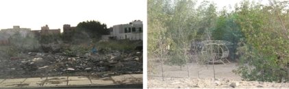
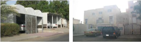
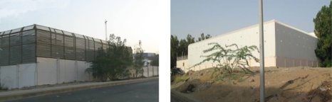
Based on trace and behaviour observation, as well as the questionnaire, the periphery open spaces constitute unsafe areas. Space syntax illustrates that they are accessible by outsiders with little compatibility with residents. Such spaces provide uncontrolled access to the project resulting in a threat for the residents. Controlling access to these spaces, a process that some residents began to do on their own, is a recommended approach. As extracted from the questionnaire, organized and clean spaces reflect the sense of security among residents and provide an inappropriate environment for criminals. Allocating and identifying specific activities for spaces encourage users to use them as intended. It is equally important to allocate open spaces to specific entities to organize and maintain them.

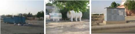
Spaces around mosques are safe during prayer time and vice versa as reported by the questionnaire. The movement to/from mosques (five times along the day) bring life to the area during prayer times and makes residents feel safe. While the lack of pedestrians in between prayer times accompanied by the existence of visual obstacles, according to trace observation, demonstrate the feeling of fear. Vegetation and rearranging visual obstacles, like water tanks and garbage containers, are expected to remedy fields of vision offering a comfortable environment for residents. Identifying areas for labour to gather in at night can keep an eye on the spaces, add courtesy and hence maintain security.

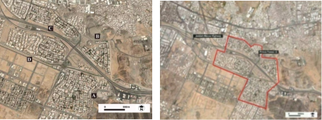
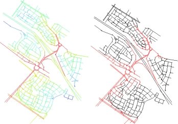
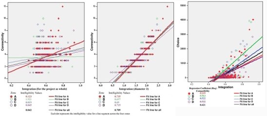
Zone A, the highest crime rate according to the questionnaire, is the most crowded according to behaviour observation and the most accessible and penetrated according to Space Syntax. But, the agreement between residents and strangers’ movement is the least. This emphasizes the fact that strangers' presence or movement through the residential area has limited influence on crime when they are accompanied by residents. On contrary, the absence of residents provides an opportunity for crime in spaces mostly accessed by strangers. This is typical with spaces around shops. It is recommended, thus, to reformulate movement routes to drive strangers to routes used by residents (integration core). Otherwise, the integration core could be re-allocated to penetrate the four zones instead of surrounding them; and pass by the commercial zone and mosque in each zone. This is expected to enhance intelligibility across the project encouraging movement on carefully selected spines that are compatible with residents’ movement. Zone A, in specific, requires more compatibility between residents and strangers’ movement to provide an adequate level of surveillance. The rest of the areas, with low intelligibility values, could be turned into controlled private and semi-private entities to block strangers to navigate through.

Comparing zone, A, the highest crime rate according to the questionnaire, with zone B and D, the least in crime rate, raises the issue of size and population of housing development. Results advocate small scale development with a straightforward urban pattern.  

Fear of crime can be generally eliminated by providing sustainable maintenance for the project spaces and movement routes; vegetation can play a significant role herein. Protection tactics justify the low fear of crime achieved in the project despite the recorded crime rate. However, protection tactics need to be studied, examined and developed in integration with the design not imposed on it; this is an interesting future scope of research.


Acknowledgement

This article was funded by the Deanship of Scientific Research (DSR) at King Abdulaziz University, Jeddah. The author, therefore, acknowledges with thanks DSR for technical and financial support.


Conflict of interests

The author declares no conflict of interest.


References

Abdullah Eben Saleh, M. (1999). Reviving traditional design in modern Saudi Arabia for social cohesion and crime prevention purposes. Landscape and Urban Planning, 44(1), 43-62. https://doi.org/10.1016/S0169-2046(98)00107-8


Abu Shama, A. (2007). Violence crime and methods of facing it in the Arab countries. Riyadh: Naif Arab Academy for Security Sciences. (Arabic).


Adel, H., Salheen, M., & Mahmoud, R. A. (2016). Crime in relation to urban design. Case study: The Greater Cairo Region. Ain Shams Engineering Journal, 7(3), 925-938. https://doi.org/10.1016/j.asej.2015.08.009


Al Beshr, K. (2000). Fighting crime in the Kingdom of Saudi Arabia. Naif Arab Academy for Security Sciences. (Arabic).


Al Hazza', W. (2001). Affordable housing Seminar on Future of Housing in the City of Riyadh, The High Commission for the Development of Riyadh, Riyadh. (Arabic).


Anna Alvazzi del Frate, J. N. (Ed.). (1993). Environmental Crime, Sanctioning Strategies, and Sustainable Development. United Nations Interregional Crime and Justice Research Institute.


Austin, D. M., Furr, L. A., & Spine, M. (2002). The effects of neighborhood conditions on perceptions of safety. Journal of Criminal Justice, 30(5), 417-427. https://doi.org/10.1016/S0047-2352(02)00148-4


Ballintyne, S., Pease, K., & McLaren, V. (Eds.). (2000). Secure Foundations: Key Issues in Crime Prevention, Crime Reduction and Community Safety. Institute for Public Policy Research.


Bartol, C. R., & M., B. A. (Eds.). (2006). Current perspectives in forensic psychology and criminal justice. USA: Sage Publications.


Branas, C. C., Cheney, R. A., MacDonald, J. M., Tam, V. W., Jackson, T. D., & Ten Have, T. R. (2011). A Difference-in-Differences Analysis of Health, Safety, and Greening Vacant Urban Space. American Journal of Epidemiology, 174(11), 1296-1306. https://doi.org/10.1093/aje/kwr273


Brown, B. B., & Altman, I. (1983). Territoriality, defensible space and residential burglary: An environmental analysis. Journal of Environmental Psychology, 3(3), 203-220. https://doi.org/10.1016/S0272-4944(83)80001-2


CNU. (2001). Charter of the new urbanism. New York: Congress for the New Urbanism.


Cozens, P., Hillier, D., & Prescott, G. (2001). Crime and the design of residential property – exploring the perceptions of planning professionals, burglars and other users: Part 2. Property management, 19(4), 222-248. https://doi.org/10.1108/EUM0000000005784


Cozens, P. M. (2002). Sustainable Urban Development and Crime Prevention Through Environmental Design for the British City. Towards an Effective Urban Environmentalism for the 21st Century. Cities, 19(2), 129-137. https://doi.org/10.1016/S0264-2751(02)00008-2


Donovan, G. H., & Prestemon, J. P. (2010). The Effect of Trees on Crime in Portland, Oregon. Environment and Behavior, 44(1), 3-30. https://doi.org/10.1177/0013916510383238


El-Torky, M. (2015). Reduction of crime rates in Saudi Arabia by 10% in the Past Year. Aleqtisadiah, 8035, 11 October. Riyadh: Saudi Research and Publishing Company. (Arabic).


Elbadawi, I. (1991). The role of planning in promoting safer communities. Canada: Dalhousie University.


Elgarmadiand, A. S., & Özer, Ö. (2018). The relationship of crime to the street network using the space syntax theory, Case study Al-khums City-Libya. International Journal of Latest Research in Humanities and Social Science (IJLRHSS), 1(7), 21-27. http://www.ijlrhss.com/paper/volume-1-issue-7/4.HSS-164.pdf


Elshater, A. (2012). New Urbanism Principles versus Urban Design Dimensions towards Behavior Performance Efficiency in Egyptian Neighbourhood Unit. Procedia - Social and Behavioral Sciences, 68, 826-843. https://doi.org/10.1016/j.sbspro.2012.12.270


Foster, S., Hooper, P., Knuiman, M., Bull, F., & Giles-Corti, B. (2016). Are liveable neighbourhoods safer neighbourhoods? Testing the rhetoric on new urbanism and safety from crime in Perth, Western Australia. Social Science & Medicine, 164, 150-157. https://doi.org/10.1016/j.socscimed.2015.04.013


Ghani, Z. A. (2017). A comparative study of urban crime between Malaysia and Nigeria. Journal of Urban Management, 6(1), 19-29. https://doi.org/10.1016/j.jum.2017.03.001


Ha, T., Oh, G.-S., & Park, H.-H. (2015). Comparative analysis of Defensible Space in CPTED housing and non-CPTED housing. International Journal of Law, Crime and Justice, 43(4), 496-511. https://doi.org/10.1016/j.ijlcj.2014.11.005


Hagan, F. E., & Daigle, L. E. (2018). Introduction to Criminology: Theories, Methods, and Criminal Behavior. SAGE Publications.


Harcourt, B. E. (2009). Illusion of Order: The False Promise of Broken Windows Policing. Harvard University Press.


Hardy, K. M. (1997). Crime prevention through environmental design: A comparative analysis of two Las Vegas apartment complexes (Nevada) School of Architecture, College of Fine Arts

University of Nevada]. Las Vegas. https://www.elibrary.ru/item.asp?id=5567144


Hillier, B. (2004). Can streets be made safe? URBAN DESIGN International, 9(1), 31-45. https://doi.org/10.1057/palgrave.udi.9000079


Hillier, B., & Sahbaz, O. (2005). High Resolution Analysis of Crime Patterns in Urban Street Networks: an initial statistical sketch from an ongoing study of a London borough.


Hillier, B., & Sahbaz, O. (2008). An evidence based approach to crime and urban design, or, can we have vitality, sustainability and security all at once. Bartlett School of Graduates Studies University College London, 1-28.


Kuo, F. E., & Sullivan, W. C. (2001). Environment and Crime in the Inner City: Does Vegetation Reduce Crime? Environment and Behavior, 33(3), 343-367. https://doi.org/10.1177/0013916501333002


Lacoe, J., Bostic, R. W., & Acolin, A. (2018). Crime and private investment in urban neighborhoods. Journal of Urban Economics, 108, 154-169. https://doi.org/10.1016/j.jue.2018.11.001


Lorenc, T., Clayton, S., Neary, D., Whitehead, M., Petticrew, M., Thomson, H., Cummins, S., Sowden, A., & Renton, A. (2012). Crime, fear of crime, environment, and mental health and wellbeing: Mapping review of theories and causal pathways. Health & Place, 18(4), 757-765. https://doi.org/10.1016/j.healthplace.2012.04.001


Maas, J., Spreeuwenberg, P., van Winsum-Westra, M., Verheij, R. A., Vries, S., & Groenewegen, P. P. (2009). Is Green Space in the Living Environment Associated with People's Feelings of Social Safety? Environment and Planning A: Economy and Space, 41(7), 1763-1777. https://doi.org/10.1068/a4196


Malleson, N., & Birkin, M. (2012). Analysis of crime patterns through the integration of an agent-based model and a population microsimulation. Computers, Environment and Urban Systems, 36(6), 551-561. https://doi.org/10.1016/j.compenvurbsys.2012.04.003


Marques, S. C. R., Ferreira, F. A. F., Meidutė-Kavaliauskienė, I., & Banaitis, A. (2018). Classifying urban residential areas based on their exposure to crime: A constructivist approach. Sustainable Cities and Society, 39, 418-429. https://doi.org/10.1016/j.scs.2018.03.005


Marvi, L. T., & Behzadfar, M. (2015). Local Sustainability with Emphasis on CPTED Approach, The Case of Ab-kooh Neighborhood in Mash-had. Procedia - Social and Behavioral Sciences, 201, 409-417. https://doi.org/10.1016/j.sbspro.2015.08.194


McCord, E. S., Ratcliffe, J. H., Garcia, R. M., & Taylor, R. B. (2007). Nonresidential Crime Attractors and Generators Elevate Perceived Neighborhood Crime and Incivilities. Journal of Research in Crime and Delinquency, 44(3), 295-320. https://doi.org/10.1177/0022427807301676


Mohit, M. A., & Hannan, M. H. E. (2012). A Study of Crime Potentials in Taman Melati Terrace Housing in Kuala Lumpur: Issues and Challenges. Procedia - Social and Behavioral Sciences, 42, 271-283. https://doi.org/10.1016/j.sbspro.2012.04.191


Nasar, J. L., Fisher, B., & Grannis, M. (1993). Proximate physical cues to fear of crime. Landscape and Urban Planning, 26(1-4), 161-178. https://doi.org/10.1016/0169-2046(93)90014-5


Nasar, J. L., & Jones, K. M. (1997). Landscapes of Fear and Stress. Environment and Behavior, 29(3), 291-323. https://doi.org/10.1177/001391659702900301


Newman, O. (1972). Defensible space: crime prevention through urban design. New York: Macmillan.


Nubani, L., & Wineman, J. (2005, 2005). The role of space syntax in identifying the relationship between space and crime Proceedings of the 5th Space syntax Symposium on Space Syntax, Delft, Holland. http://spacesyntax.tudelft.nl/media/Long%20papers%20I/lindanubani.pdf


OSAC. (2019). Saudi Arabia 2019 Crime & Safety Report: Jeddah. https://www.osac.gov/Country/SaudiArabia/Content/Detail/Report/29856272-46df-49b5-8c3c-15f4aeafb5da


OSAC. (2020). Saudi Arabia 2020 Crime & Safety Report: Riyadh. https://www.osac.gov/Country/SaudiArabia/Content/Detail/Report/f6af335c-d5b7-4087-9086-186575bdfb0f


Pietenpol, A. M., Morgan, M. A., Wright, J. P., Almosaed, N. F., Moghrabi, S. S., & Bashatah, F. S. (2018). The enforcement of crime and virtue: Predictors of police and Mutaween encounters in a Saudi Arabian sample of youth. Journal of Criminal Justice, 59, 110-121. https://doi.org/10.1016/j.jcrimjus.2018.05.007


Piroozfar, P., Farr, E. R. P., Aboagye-Nimo, E., & Osei-Berchie, J. (2019). Crime prevention in urban spaces through environmental design: A critical UK perspective. Cities, 95, 102411. https://doi.org/10.1016/j.cities.2019.102411


Robinson, P. E. M. (1997). Places of crime and designing for prevention: a study of York University Campus. Ontario: York University.


SABQ. (2017, 13 October 2017). Decline of crime in Saudi Arabia: security alert, awareness of society and a state that imposed its prestige with justice. (Arabic). . SABQ online newspaper.


Sakip, S. R. M., & Abdullah, A. (2012). Measuring Crime Prevention through Environmental Design in a Gated Residential Area: A Pilot Survey. Procedia - Social and Behavioral Sciences, 42, 340-349. https://doi.org/10.1016/j.sbspro.2012.04.198


Serpas, R. W. (1998). Common-sense approaches with contradictory results: Does defensible space curb crime? (Publication Number 9900958) [Ph.D., University of New Orleans]. ProQuest Dissertations & Theses Global; ProQuest One Academic. Ann Arbor. https://www.proquest.com/docview/304426725?pq-origsite=gscholar&fromopenview=true#


Shon, P. C. H., & Barton-Bellessa, S. (2015). The assumption of rational choice theory in Alfred Adler's theory of crime: Unraveling and reconciling the contradiction in Adlerian theory through synthesis and critique. Aggression and Violent Behavior, 25, 95-103. https://doi.org/10.1016/j.avb.2015.07.004


Soh, M. B. C. (2012). Crime and Urbanization: Revisited Malaysian Case. Procedia - Social and Behavioral Sciences, 42, 291-299. https://doi.org/10.1016/j.sbspro.2012.04.193


Sonia Hirt, & Zahm, D. L. (Eds.). (2012). The Urban Wisdom of Jane Jacobs. Routledge.


Taylor, R. B. (2001). Breaking away from broken windows: Baltimore neighborhoods and the nationwide fight against crime, grime, fear, and decline. Oxford, Westview Press.


Thacher, D. (2004). Order maintenance reconsidered: Moving beyond strong causal reasoning. The Journal of Criminal Law and Criminology, 94, 381-414.


Wilcox, P. (2015). Routine Activities, Criminal Opportunities, Crime and Crime Prevention. In International Encyclopedia of the Social & Behavioral Sciences: Second Edition (pp. 772-779). Elsevier Inc.


Wolfe, M. K., & Mennis, J. (2012). Does vegetation encourage or suppress urban crime? Evidence from Philadelphia, PA. Landscape and Urban Planning, 108(2), 112-122. https://doi.org/10.1016/j.landurbplan.2012.08.006


Yazdanfar, S. A. A., & Nazari, N. (2015). Proposed Physical-environmental Factors Influencing Personal and Social Security in Residential Areas. Procedia - Social and Behavioral Sciences, 201, 224-233. https://doi.org/10.1016/j.sbspro.2015.08.171


Zen, I., & Mohamad, N. A. A. (2014). Adaptation of Defensible Space Theory for the Enhancement of Kindergarten Landscape. Procedia - Social and Behavioral Sciences, 153, 23-35. https://doi.org/10.1016/j.sbspro.2014.10.037


Appendix

In a network of potential lines of movement, “connectivity” represents the possible paths that link any two locations. While, “integration” is a measure of closeness-centrality; it identifies the streets that minimize directional or metric distances from all possible destinations. It is a normalized measure of distance from any "a space of origin" to all others in a system. In general, it calculates how close the origin space is to all other spaces and can be seen as the measure of relative asymmetry (or relative depth). Spaces, thus, are arranged from highly integrated (indicated with red) to highly isolated (indicated with blue). Integrated spaces are those easily accessed from everywhere of the project and vice versa. “Integration core” is a pattern made of the 10%, 25% or 50% most integrating spaces.

“Intelligibility” represents degree of correlation between connectivity and global integration values of the axial lines in spatial configuration analysis. The high correlation between connectivity and integration ensures that the spatial configuration is understandable and predictable for the pedestrian or vehicular movement. Axial intelligibility indexes the degree to which the number of immediate connections a line has is a reliable guide to the importance of that line in the system as a whole. A strong correlation, or ‘high intelligibility’, implies that the whole can be read from the parts.

“Choice” measures how likely an axial line or a street segment it is to be passed through on all shortest routes from all spaces to all other spaces in the entire system or within a predetermined distance (radius) from each segment. While, “depth” exists wherever it is necessary to go through intervening spaces to get from one space to another.


How to cite this article:

Attia, M. (2021). Enhancing Security in Affordable Housing: The Case of Prince Fawaz Project.  Journal of Contemporary Urban Affairs, 5(1), 85-100. https://doi.org/10.25034/ijcua.2021.v5n1-8


*Corresponding Author:

Department of Architecture, Faculty of Architecture and Planning, King Abdulaziz University, Jeddah, KSA

Email address: mattia@kau.edu.sa


This article is an open access

article distributed under the terms and conditions of the Creative Commons Attribution (CC BY) license

C:\Users\Hourakhsh\Desktop\CC_By_2020_licnece1.jpg

This article is published with open access at www.ijcua.com


[1] The local measure proximity diameter 3 looks at the intelligibility of the 3 closest axial lines from the starting axial line; a distance which is appropriate for walking. A high (diameter 3) intelligibility implies that a line segment and the 3 closest axial lines are important for pedestrian movement through the system; or that the area can be conceived from these parts.