How to Cite this Article:
WANG, H., NEWMAN, G., & WANG, Z. (2019). Urban Planning as an Extension of War Planning. Journal of Contemporary Urban Affairs, 3(1), 1-12. https://doi.org/10.25034/ijcua.2018.4677
Journal Of Contemporary Urban Affairs
2019, Volume 3, Number 1, pages 1– 12
Urban Planning as an Extension of War Planning: The Case of Shenyang,
China, 1898-1966
* Dr. Huaqing Wang 1, Dr. Galen Newman 2, Dr. Zhifang Wang 3
1 & 2 Department of Landscape and Urban Planning, Texas A&M University, USA
3 College of Architecture and Landscape Architecture, Peking University, China
1 Email: huaqingwang452@gmail.com 2 Email: gnewman@arch.tamu.edu 3 Email: zhifangw@pku.edu.cn
*Corresponding Authors:
Department of Landscape and Urban Planning, Texas A&M University, USA
E-mail address: huaqingwang452@gmail.com
Article history:
Received 20 March 2018 Accepted 23 April 2018 Available online 15 June 2018
Keywords:
Urban Morphology; Chinese History; Space Syntax; Military Event.
A B S T R A C T
War-city relationships had long been studied by scholars regarding wars’ sudden impact on cities. Studies typically focused on one specific event’s impact on urban military, politics, economy, or society. This approach, however, treated war’s impact on cities as only temporary, hindered opportunities to reveal multiple political regimes’ spatial competition through war-oriented city planning and construction, which is crucial for city development, and their resultant urban form changes through time. In response, this study has examined city planning and construction activities during the short time gaps between multiple military conflicts, with various military objectives, and conducted by different political regimes in Shenyang, China. In accordance with archival research, a space syntax axis analysis has been used to quantify spatial dynamics throughout war-peace-war cycles to explore the impact of military-oriented planning on city-scaled development. We have found these planning strategies, initiated by specific military goals, acted as extensions of war planning, segregating the city and causing urban fragmentation. They also acted as a driving factor which promoted modernization of the city in the early 20th century. We conclude that wars oriented planning can alter a city’s development track and impact its structure and form through the creation of internally connected but isolated urban districts.
JOURNAL OF CONTEMPORARY URBAN AFFAIRS (2019), 3(1), 1-12.
https://doi.org/10.25034/ijcua.2018.4677
www.ijcua.com
Copyright © 2018 Journal Of Contemporary Urban Affairs. All rights reserved.
-
Introduction
The link between mass violence and cities is strong and complex (Schachtschabel, 2005). A variety of studies explored war’s impact on cities by analysing the life of specific groups of residents, such as women, refugees, war prisoners, and relocations, and/or focused on the impact of wars on cities through analysing destruction or reconstruction of urban areas from economic, sociological or political perspectives (Christian Henriot, 20017; Diefendorf, 1993; Henriot, 2006 Nelson, 2012). Most of these studies examine wars as disasters to urban form and layout (Bishop and Clancey, 2004).
Studies on relationship between war and city development typically focus on one particular military event or city status after a series of wars, in a relatively short time period; these studies are conducted primarily qualitatively and with little analysis of spatial change (Alexander, 2000; Brakman et al., 2004; Hardy, 1989; Henriot, 2017). Glaser and Shapiro conducted an overview of war-city relationships and concluded that wars may not significantly alter city form, and that the impact of terrorism on cities may be smaller than previously thought (Glaeser and Shapiro, 2002). Roger Lotchin conducted a comprehensive qualitative analysis on the impact of World War II on San Francisco, Los Angeles, Oakland, and San Diego, concluding that WWII was a Heroic Interlude in each city’s developmental history (Lotchin, 2003). Sanso-Narro etc., used demographic measures of city growth as explanatory variables to measure war-city relationships, and concluded that the impacts from war shock on city growth were transitory (Sanso-Navarro et al., 2015). However, focusing on only one war event hinders opportunities to reveal multiple wars’ spatial competition through city planning and construction. In response, this study seeks to answer, how does the resultant urban form due to war planning affect the internal and external connectivity of cities experiencing wartime? Through this, we unveil the role these war-planning activities play in city development.
The city of Shenyang, China was selected as a study area for numerous salient reasons. First, Shenyang experienced five major wars and invasions from 1898-1966. Similar to colonialism, these wars arose as the result of territories being settled by foreign powers. A variety of different city planning and construction projects were implemented during the short periods of peacetime between wars, primarily because war parties sought to exert total and permanent control over territories and population and tried to ensure lasting stability (de Moor and Wesseling, 1989). Meanwhile, planning approaches had clear military goals both spatially and operationally, aiming at efficiently producing war necessities. This circumstance provides a chance to examine how military oriented planning can impact city development. Secondly, historically, Shenyang was a partial port city containing attached and small areas of land inside the city for foreigners to rent and implement construction projects (Hou and Zhang, 2001). This provides a vista into how city planning by invaders can influence domestic planning practices.
The study crosses the boundaries of historicism, the cultural/political implications involved with wars, planning and their following urban form change on a longitudinal time scale to increase information about relationships of military, planning and city development. Additionally, the utilization of the space syntax method in historical research, extends the military planning focus beyond the previously cultural, economic and archaeology fields (Griffiths, 2012 and Griffths ,2011). To the best of our knowledge, few studies have analysed how military oriented planning and construction have altered city development between various wars longitudinally, spatially and quantitatively.
-
Space Syntax and the Indices Adopted
To untangle Shenyang’s rich spatial tapestry, we adopted a quantitative space syntax axis analysis and integrated these findings into a historical interpretive analysis based on archival research. The focus of the socio-spatial dimensions of space syntax theory made it an optimum method for analyzing the relationship between planning, its resultant city form and how city operates. The logic behind space syntax is that human societies use space as a necessary resource in organizing themselves (Bafna, 2003), and spatial configuration explains a substantial proportion of the variance between human movement rates in different locations in urban space (Bafna, 2003; Hillier, 1987). At the city scale, street axis analysis of space syntax is an objective method to describing, comparing, and interpreting urban form characteristics (Ahmed et al., 2014).
We adopted two indices of space syntax axis analysis in this study. These integration indices are being used and shown to be valid by a growing number of city form studies in exploring city types, city core areas, and relationship between social events and physical form of city. Omer and Zafrir-Reuven found that cities belonging to the same region tended to exhibit similar local levels of spatial integration and significant syntactic differences appeared at a global level (Omer and Zafrir-Reuven, 2010). Giannopoulou et al. successfully confirmed the location and extent of the commercial and administrative center of Xanthi city, also finding differences in local and global levels (Giannopoulou et al., 2012). Froy found that commercial activities typically took advantage of distributed spatial configurations of the some cities and spread out across the street network, by analysing spatial organization of economic activities in early 19th century (Froy, 2016). Nattasit and Nobuo used integration analysis and found urban axes highly coexisted with city historical contents by examining how historical geo-political issues influenced urban axes and
street networks in ‘Lan Na’ historic city in northern Thailand (Srinurak and Mishima, 2017).
The first adopted indicator in this study, Integration Value (IV) (Wu et al., 2015), reflects the degree of aggregation or dispersion of a unit in space. A higher Local Integration Value (LIV) indicates higher accessibility to the place and refers to more people on the site with high movement rate. The location of the city core area can be reflected by the location where high IV streets accumulate, especially in a Global Integration Map (GIV). The second index used in this study is the R2 parameter, which reflects how well the LIV correlated with GIV in a city. In our case, the lower the R2 value, the more various urban forms are contained by a city and the city would be spatially more fragmented (B. Hillier et al.,1987; W. R. G. Hillier et al., 1993).
-
Shenyang: Military activities and political regimes supersession
Shenyang, historically referred to as Mukden, is located in northeast China. It is currently the provincial capital and largest city within the Liaoning Province. It was one of the largest cities to have continuously experienced a series of large-scale warfare in modern China (primarily from 1898-1948), creating a continual war-peace-war cycle with various urban planning practice. The following set of paragraphs describes the major wars occured in Shenyang during this period.
Russian Convention: Shenyang became a Russian stronghold in China with the building of the South Manchurian Railway (Tietze, 2003) because of the sign of Sino–Russian Secret Treaty in 1896 and the Pavlov Agreement in 1898. The treaty allowed Imperial Russia to build a Russian gauge railway in Manchuria (Nish, 2014). It was signed by Qing Viceroy Li Hongzhang and Russian foreign minister Alexey Lobanov-Rostovsky in Moscow under the aftermath of the Japanese threat after the First Sino-Japanese War (1894-1895).
Russo-Japanese War: The introduction of Russian power into Shenyang encouraged the initialization of the Russo-Japanese War. It occurred from February 19-March 10, 1905 and was the largest modern-era battle ever fought in Asia prior to World War II. This war was fought between the Russian Empire and the Empire of Japan over rival imperial ambitions in Manchuria and Korea involving more than 600,000 combat participants. Following the Japanese victory, Mukden (Shenyang) became one of the chief bases of Japan on their way of invading China. Japan took control of the Russian built branch line of the South Manchurian Railway line which traversing through Shenyang city.
Warlord Zhang and the Huanggutun Incident: In 1920, the Chinese Central Government appointed Zhang Zuolin as Governor-General of the three eastern provinces, who eventually became the supreme ruler of Manchuria as a warlord. Zhang acted as an anti-Japanese force in Shenyang. To support his army, he initiated a variety of city planning and construction projects to both promote economic development and spatially restrict Japan from further expansion into other areas of Shenyang. However, this action caused Zhang’s death due to assassination from the Japanese in 1928, this event is known as the Huanggutun Incident, which acted as the pretext of Mukden Incident (Jian, 2010).
Mukden Incident: On Sept.18, 1931, the incident was a staged event engineered by Japanese military personnel as a pretext for the Japanese invasion (Hata and Coox, 1988). After the Mukden Incident, Shenyang, whose area is three times the area of Japan, became a colony of Japan and its economic and military base. A variety of specific military oriented planning were then implemented. After occupying Shenyang, Japan further attacked towards the south and on January 28, 1932, the Japanese army attacked Shanghai (Treat, 1940). This expansion caused a counterattack from Chinese people, beginning in 1937 (Henriot, 2012).
Chinese People's War of Resistance against Japanese Aggression: This was a military conflict fought primarily between the Republic of China and the Empire of Japan from 1937 to 1945 (Hough et al., 2012). It was an important part of the international anti-Fascist war, but not until 1943 was Shenyang brought back to the Chinese from Japan. In this year, the Allies of World War II decided to restrain and punish the aggression of Japan by restoring all the territories that Japan annexed from China, including Shenyang (Wright, 1955).
Liaoshen Campaign: Only five years after droving out the Japanese army, in 1948, the Chinese Civil War passed through Shenyang as the Liaoshen Campaign. This campaign was the first of the three major campaigns launched by the People's Liberation Army (PLA) during the late stage of the Chinese Civil War. The PLA defeated the Nationalist forces and liberated Shenyang.
-
Military controlled planning and space syntax analysis
Table 1. Military events and their raised plan and construction projects
|
Event
|
Event year
|
Planning party
|
City plan and their implemented year
|
Construction completed
|
Map year
|
|
Russian convention
|
1898
|
Russian
|
Railway station (1898-1904)
|
Railway line and station
|
1911
|
|
Russo-Japanese War
|
1905
|
Japanese
|
City-Streets plan (1907)
|
Railway attached land
|
1919
|
|
Zhang Zuolin as Governor-General
|
1920
|
Zhang’s government
|
General rules of Fengtian commercial port (1921)
|
Commercial port
|
1927
|
|
Da-Dong industrial district plan (1919, 1928);
Hui-Gong industrial district plan (1923);
Feng-Hai plan (1926)
|
Industrial districts
|
1939
|
|
Mukden Incident
|
1931
|
Japanese
|
Fengtian City Plan (1938)
|
Tie-xi Industrial District
|
1946
|
|
Liaoshen Campaign
|
1948
|
Chinese government
|
Preliminary Plan of Shenyang (1956)
|
Overall fast urbanization
|
1966
|
Within the short peace gaps between wars, various city planning and construction projects were implemented (Table 1). Maps of Shenyang were selected and digitalized in AutoCAD, and then analyzed in space syntax software Depthmap-0.50. These maps include Shenyang maps in 1911, 1919, 1927, 1939, 1946, and 19661. These maps were selected according to their availability and their ability to reflect the urban form of each developing stage between wars in the city history.
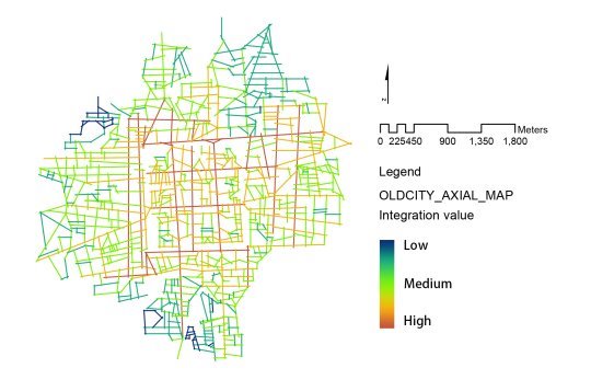
Figure 1. GIV of Shenyang old city.
Before the Russian convention, during the late Qing Dynasty, Shenyang was formed with Imperial Palace as city centre. This palace was built in 1625 and belonged to the Manchu noble family, which built the Qing Dynasty in Shenyang. The boundary of the palace was the inner-city wall of Shenyang, which is also the city core area (Figure 1). Outside of this wall, the city was mainly formed and planned by its residents. Because the primary transportation method for residents was walking, the road system showed a human scale organic form, developed very balanced towards all spatial directions (Figure 1). This planning logic resulted in a largely circular formed city. At the periphery of the city, an outer city wall was built to protect city residents. The road network structure inside and out of the palace was different, which, according to the space syntax analysis, captured by an R2 value of 0.70 (the value should approach 1.0 when the road network is very similar). City infrastructures for ordinary residents were not as good as those inside the palace. Palace roads were paved with stone, while city roads outside it were unpaved with soil as the surface. Most city buildings, other than imperial structures and religious architectures, were single-story. Ordinary residents used candles for lighting and well water lifted by manpower or animals acted as water source.
After the Russian Convention, in 1911, Russia began to build railway lines in the west and they needed workers. Local residents began to commute between the old city and the railway line area to work. These commutes formed several main streets in between the two areas on a much larger scale than previous growth. The city began developing westward. Small-scale road network accessibility stayed fairly weak with a medium to low level LIV (Figure 2). From a road network perspective, the organic form of the old city hindered the direct road connection towards the west. The newly formed roads brought different road structures to the city and the R2 accurately captured this change by decreasing slightly from 0.7 to 0.67.
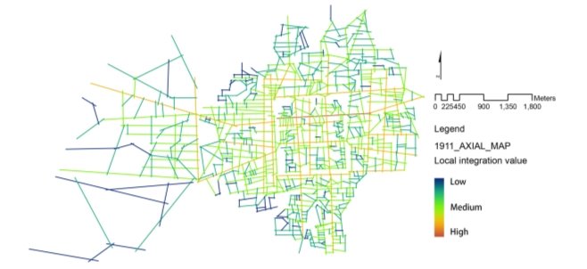
Figure 2. LIV of Shenyang 1911.
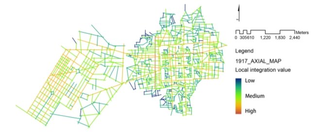
Figure 3. LIV of Shenyang 1919
After the Russo-Japanese War in 1905, Japan controlled the railway and aimed at developing the occupied cities into chief bases to further invade China and for Japanese to settle down. A series of city plan were made, during 1907-1909, for the 15 major cities along this railway line. Shenyang ‘s railway zone (also named the Railway Attached Land, or RAL) is the largest one among them according to its area. It was built during 1907 to around 1931. The plan for the RAL took the railway station as its centre, the merging point of three radial distributed main streets. The plan of these main streets adopted a typical Baroque style of axial planning with round public squares and gathering points. Other secondary road structures adopted traditional Japanese neighbourhoods’ ‘ting’ form, which are small, rectangular blocks with a basic size of 60 x 110 meters. The road network plan guaranteed a medium level of accessibility within its district (Figure 3). While for
the whole city, this new road structure was added, and the R2 sensitively captured this change by dropping to 0.42.
For the buildings, three primary categories were planned: Japanese official institutes such as banks and police stations; railway related functional buildings such hotels and commercial related land uses (e.g., Fengtian Hotel); service buildings for Japanese residents such as schools, malls, and residential buildings. During the construction, a variety of laws and regulations were created and applied. Within them, Buildings and Architecture Restriction Regulations and Railway Zone Construction Rules played essential roles. They stipulated building density, land use ratios and the height of buildings along the main streets. Additionally, very advanced infrastructures were planned and constructed, including a paved road system, drainage systems, and city parks. Facilities included electricity, gas, water lines, and lighting. The drainage system contained open channels and underground drainage lines. Park design contained swimming pools, baseball yards, playgrounds and specially designed pools for children. Buildings in the RAL zone had multi-floors and adopted western building facades. The advanced city system soon brought large number of immigrants. The population increased from 2,579 in 1907 to 42,786 in 1930; in 1933, 70% of RAL’s residents were Japanese.
The RAL’s construction acted as a modern sample city area to the old city. Local Chinese were soon aware of the efficiency increases and the better living environment created by the RAL city plan. They adopted some aspects of the RAL plan, combined them with traditional Chinese philosophies, and created new city forms through the planning of the Commercial Port (CP). This CP area aimed at solving their political, military, and city problems.
By 1920, warlord Zhang Zuolin (Chang Tso-lin), also known as ‘The Mukden Tiger’, the leader of Feng faction, became the Governor-General of Shenyang. He aimed at building a strong economic base for his army and expected to promote economic development. Meanwhile, the Chinese government decided to open a commercial port, which was an area that allowed foreigners to rent land, construct buildings and conduct business. The government was willing to use commercial port, as a spatial strategy, particularly located between the RAL and the old city, to prevent the city from being overrun by the railway zone’s expansion. Because of this specific military oriented site selection, largely a ‘J’ shape area was planned (Figure 4).

Figure 4. Zones inside the Commercial Port (1) North Main
Zone (2) Main Zone (3) Vice Zone (4) Prepare Zone
The Commercial Port occupied 650 ha, including different zones (Figure 4). The prepare zone was swallowed up by the railway zone after the Mukden Incident in 1931; therefore, it followed the corresponding road structure of the railway zone. The vice zone and north main zone was planned largely following the directions of one existing main street. The main zone played an essential role in linking the grid and radial structure of the railway zone with the old city organic road system. During this time, an irregular diamonds style blocks pattern was planned. This pattern is neither radical axis form, nor grid form, but something in between. By tilting the typical grid form, it effectively kept the convenience of grid systems with a medium to high level of LIV (Figure 5) while at the same time, guaranteeing an accessibility equivalent with radical axis roads. With the development of this area, the R2 value increased from 0.42 to 0.52, illustrating an improvement of city integration and the city core transferred westward.
After the road network plan, the zone was rented out to a variety of institutes, companies, and individuals who made their own building designs and constructions. Therefore, different architecture styles co-existed in this zone. Architects from Japan, United States, United Kingdom, Germany, and France designed and constructed buildings in CP. The Main Zone accumulated foreign embassies of Japan, the United States, Germany, Russia, France, Italy, Poland, and Australia. The North Main Zone accumulated economic institutes, including HSBC Bank, Citibank, Sino-French Industrial Bank, Mobil Bank and others. The Vice Zone accumulated large numbers of local commercial civilians. Their business included restaurants, teahouses, theatres and a variety of shops(Lv and zhu, 2012). These local business owners created mixed style buildings. These buildings have traditional Chinese wood architecture with western style façades. The occurrence of these buildings shows different degrees of influence of western building styles on Chinese architecture. Additionally, the CP equipped with equivalent infrastructures with the RAL, including paved road, water supply and drainage system, public toilets and parks. The construction of CP attracted large amount of businessperson and caused a population increase from 5,868 in 1908 to 60,214 in 1930, when it came to 1933, 85% of the residents at CP are non-Chinese.
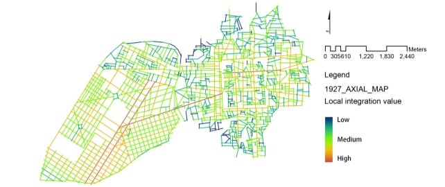
Figure 5. LIV of Shenyang 1927
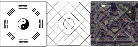
Figure 6. From left to right are (a) Eight diagrams; (b) Street structure of South Market; (c) Arial image of South Market2.
South Market in the Commercial Port is an example of Chinese people merged western city form and Chinese philosophy into urban planning. It was developed in the 1920s. The design was based on the ‘eight diagrams’ (Ba Gua) idea from I Ching (易经), which is an ancient divination text and the oldest of the Chinese classic. The eight-diagrams is also one of the classical ancient Chinese war tactics (mair, 2008). The initial idea of utilizing this military tactic into planning was raised by Tang Yulin and Wu Junsheng, who were Zhang’s military officers. Based on their idea, He Yiwu, who is the chief of engineering department of commercial port bureau, planned the South Market. Ideas of western axis and circles were used to create a form that followed Chinese philosophy (Figure 6). Additionally, the form of this plan successfully supported the city function of this area. It is commonly believed by the Chinese that battle arrays, urban areas, or other spatial structures following Ba Gua form are easy for people to enter into and hard for one to get out. When you are inside the South Market area, the buildings in eight directions (the east, west, south, north, northeast, southeast, northwest, and southwest directions) all look exactly the same, making people feel as though they are inside a labyrinth, becoming easily disoriented. For the market, this form succeeded in promoting more consumption as
consumers spent more time here because they kept getting lost and attracted by other commerce.
Figure 7. Spatial locations of RAL, old city, and industrial districts (1) Hui-gong Industrial District; (2) Shen-hai Industrial District; (3) RAL; (4) Old city; (5) Da-dong Industrial District.
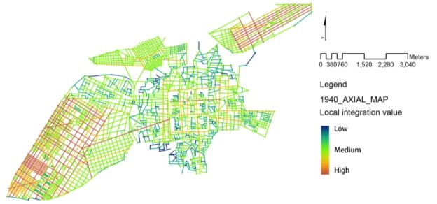
Figure 8. LIV of Shenyang 1939.
Besides promoting the economy, Zhang also planned to strengthen military and break the railway transportation control from Japan. As it became difficult to redevelop the old circle city, he transferred the focus of development to the north and east, away from the Japanese controlled area. Railway lines and several industrial districts were planned, including the Hui-gong industrial district, the Shen-hai Market district, and the Da-dong Weaponry industry district (Figure 7). Among them, the Da-dong district was spatially furthest away from the Japanese controlled railway zone and was specifically planned for producing weapons. It was fully controlled and operated by Zhang’s military. Hui-going district contained military industry enterprises as well as civilian-run enterprises. The Shen-hai district was the nearest to Zhang’s controlled railway line and was only rentable to Chinese businessmen. The urban street plan of these districts uses a combination of circles, squares, and radial axis combined with grid blocks, which almost copied the road network of railway zone. These industrial districts were well accessible within each, floating at the periphery of the city. With these additions, however, the city became more fragmented with an R2 of 0.15.
After the Mukden Incident, Japan occupied the entire territory of Shenyang. They planned to develop the city into an industry base in order to support further military actions. In 1938, Japanese professional urban planners published a plan for Shenyang entitled the Feng-tian City Plan. It was the first general plan of Shenyang that took the entire city territory into consideration, rather than pursuing single parcel or district scale development. Ideas of The
Charter of Athens, the Garden Cities movement, and Haussmann’s renovation of Paris, influenced this plan (Leng and Yuan, 2007), a typical planned and constructed area is Tie-xi Industrial District.
The Tie-xi industrial district was planned at the west next to the railway line and occupied 1150 ha of land. A pure grid net road system was planned. During the planning process, a modern zoning/divisional planning method, which includes sub-level hierarchical policy plans after the master plans, was used. These sub-plans detailed out the broad objectives of the master plan at a comparatively smaller region. Internationally, the initial zoning idea was first drafted in 1928 in the Standard City Planning Enabling Act in the United States (Haar, 1955). Only ten years after, the Shenyang Tie-xi district plan adopted it, dividing the area into two zones. The northern portions of the area were factory zones designed with 200-250 x 150 meters’ large blocks. Residential zones were located in the south at a size of 140 x 70 meters’ blocks. This grid form achieved a highly accessible city area with high LIV lines accumulated in it (Figure 9).
Shenyang liberated in 1948 and the warring ceased. Mao Zedong took the principle of New China, stressing that development and industrialization were the highest priority (Qian, 2016). Because of the previous 50 years of city planning and construction activities implemented by Russian, Japanese, and Chinese people, Shenyang became one of the most highly urbanized and industrialized cities in China. Therefore, in 1956, when a Preliminary Plan of Shenyang was constructed, it prioritized Shenyang as a heavy industrial city, following
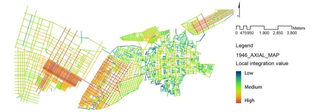
Figure 9. LIV of Shenyang 1946.
Table 2. A summary of city construction status in Shenyang history.
|
Map year
|
Constructions
|
Architecture
|
Infrastructures
|
City forms
|
Spatial directions of city development
|
R2
|
Modernization
|
|
1911
|
Railway
|
Residential, single-storey, traditional Chinese style,
|
Railway, unpaved road, well water, candles for lighting,
|
Organic
|
West
|
0.67
|
Transportation
|
|
1919
|
Railway Attached Land (RAL)
|
Residential, two/more stories, western style
|
Drainage, paved roads, parks; electricity, gas, tap water lines, and electric lighting
|
Ting, axial, round squares, points
|
West
|
0.42
|
Started modern urbanization
|
|
1927
|
Commerical Port
|
Commercial two/more stories, western combined with Chinese style
|
Equivalent to RAL
|
Diamond, eight-diagrams form
|
Balanced
|
0.52
|
Further
urbanization
|
|
1939
|
Shenhai, Dadong,Huigong, Industrial Districts
|
Industrial & residential, one/more stories, western style,
|
Equivalent to RAL
|
Circles, squares, radial axis, grid
|
North, south & east
|
0.15
|
Started industrialization
|
|
1946
|
Tie-xi District
|
Industrial & residential, one/more stories, western style,
|
Equivalent to RAL without Parks
|
Grids (two different zoning sizes)
|
West
|
0.13
|
Further industrialization
|
|
1966
|
Revitalization of old city, & expansion
|
Industrial, residential & commercial, Multi-level, modern
|
Equivalent to RAL + other modern facilities
|
Grid, Change organic form into grids
|
North, south & east
|
0.62
|
Overall fast urbanization
|
Mao’s vision (Tang, 2000). Spatially, other than expanding a grid form towards the north, south, and east, another important urban practice was the revitalization and reconstruction of the old circle city area in 1966. The plan removed the organic road system and adopted a largely grid form that could merge into other portions of the city. This helped integrate and re-connect the city holistically, which can be seen by a sharply increasing R2 to 0.62 (Table 2).
-
Discussion and conclusion
This study sought to determine how urban form due to war planning affects the internal and external connectivity of cities experiencing wartime. ‘War and the city have intimately shaped each other throughout urban and military history’ (Graham, 2004). Repeated internal and external colonial wars throughout Shenyang’s history have created a unique urban planning and construction process. These city plans influenced urban morphology by affecting their internal and external connectivity and site selection of new districts, which caused fragmentation. They also directly and indirectly, promoted the modernization of Shenyang.
War-oriented city planning in Shenyang provided a chance for the city to begin to rapidly urbanize nearly 40 years ahead of other cities in China. Since the building of the railway attached land, the urbanization process initiated and city infrastructure improved. Water resource changed from well water lifted by manpower or animal into tap water; lighting systems improved from candle lighting into electric lighting; transportation systems altered from lifting sedan chairs into automobiles and tram (the first line started in 1925); roads were developed from unpaved mud roads into paved roads with street trees.
These planning practices also promoted industrialization, spanning mainly from 1920 to 1943. This is far earlier than most other cities in China, which industrialized primarily from 1949-76 (Gaubatz, 1999). Wars are won by industries, labor, natural resources, transportation as well as cities’ advantages (Lotchin, 2003). City planning during warfare had specific aims, including developing industry for producing war necessities. When Zhang occupied part of Shenyang and Japan controlled the other half, the need of wars in south China expedited the planning of industrial districts in Shenyang. These industrial districts made about half of the city area into industrial regions and set the scene for Shenyang to become a heavy industrial city after 1949.
Wars segregate people, and war-planning activities can segregate cities. Continuous war oriented planning and construction activities in Shenyang history significantly increased the local integration while decreased the global integration of the city. Road network connectivity is high inside land parcels, which were gradually developed by various political regimes. This is mainly due to each regime adopting advanced planning ideals and apparently actively or passively ignoring land parcel connectivity and urban form consistency. Wars brought new religion, culture, and technology to the city and these resultant plans brought various city forms including ting, baroque, rhombus, grid, radiation, and curve to the city. It affected the internal and external connectivity and caused overall city fragmentation but also resulted in pockets of development which were highly connected internally. The fragmentation can be seen through the continuously decreasing R2 value from 1911 to 1949, from 0.7 before Japan built RAL all the way down to 0.13 after the built of Tie-xi district. These plans acted as extensions of wars in separating Shenyang city, and reflected spatial competition and segregation between political regimes. The result, a set of multiple isolated wartime developments which worked well within themselves but were detached from the city as a whole.
Additionally, planning with military aims influenced the site selection of new districts. The location of the commercial port was selected between the old city and the RAL, partly due to a military strategy to hinder Japan’s further invasion into other areas of Shenyang. The site selection of industrial districts for both Zhang and Japan was with a military concern to avoid threatening from one another. Clearly, urban planning itself became war strategy and impacted city expansion significantly. It becomes unavoidable to recognize that these colonial planning rose by military events indeed had a far-reaching influence on Shenyang’s spatial structure.
Notes
-
Shenyang map of 1911 is preserved by the National Archives of Japan. The map in 1919 is preserved in the National Diet Library of Japan. The source of Shenyang city maps in 1927, 1946 and 1966 are: Shenyang City Office of Local Chronicles Compilation Committee. Shenyang Picture Chronicles. Shenyang Press, 2012. For the map in 1939, see further: Fengtian. The vision of big Fengtian city. Fengtian city document department, 1939.
-
Bagua Jie in Shenyang. 41°47'08.68" N and 123°24'51.65" E. Google Earth. May 28, 2016. April 2, 2017.
Acknowledgment
We thank Yajun Liu, for her kind help in collecting Shenyang city maps. This research did not receive any specific grant from funding agencies in the public, commercial, or not-for-profit sectors.
Conflict of interests
The authors declare no conflict of interest.
References
Ahmed, B., Hasan, R., & Maniruzzaman, K. M. (2014). Urban morphological change analysis of Dhaka city, Bangladesh, using space syntax. ISPRS International Journal of Geo-Information, 3(4), 1412-1444. https://doi.org/10.3390/ijgi3041412
Alexander, I. (2000). The post-war city. In The Australian metropolis: a planning history (pp.98-112). New York, NY: Routlege. ISBN: 0419258108. https://books.google.com/books?id=tLSyx93RvRYC&printsec=frontcover&source=gbs_ge_summary_r&cad=0#v=onepage&q&f=false
Bafna, S. (2003). Space syntax: A brief introduction to its logic and analytical techniques. Environment and Behavior, 35(1), 17-29. https://doi.org/10.1177/0013916502238863
Bishop, R., Clancey, G. (2008). The City-as-Target, or Perpetuation and Death. In Cities, War, and Terrorism: Towards an Urban Geopolitics (pp. 54–74). Malden, MA: Blackwell Publishing. https://doi.org/10.1002/9780470753033.ch3
Brakman, S., Garretsen, H., Schramm, M. (2004). The strategic bombing of German cities during World War II and its impact on city growth. Journal of Economic Geography, 4(2), 201-218. https://doi.org/10.1093/jeg/4.2.201
Henriot, C. (2006). Shanghai and the experience of war: The fate of refugees. European Journal of East Asian Studies, 5(2), 215-245. https://doi.org/10.1163/157006106778869306
Wesseling, H.L. (1989). Colonial wars: An introduction. In Imperialism and War: Essays on Colonial Wars in Asia and Africa (pp.1-11). Leiden, The Netherlands: E.J. Brill: Universitaire pers Leide. ISBN: 9004088342. https://books.google.com/books?printsec=frontcover&vid=ISBN9004088342#v=onepage&q&f=false
Diefendorf, J.M. (1993). In the wake of war: the reconstruction of German cities after World War II. New York, NY: Oxford University Press. ISBN: 0195072197. https://doi.org/10.1080/03612759.1994.9949002
Froy, F.E. (2016). Understanding the spatial organisation of economic activities in early 19th century Antwerp. The Journal of Space Syntax, 6(2), 225-246. http://joss.bartlett.ucl.ac.uk/journal/index.php/joss/article/view/287/pdf
Gaubatz, P. (1999). China’s urban transformation: patterns and processes of morphological change in Beijing, Shanghai and Guangzhou. Urban studies, 36(9), 1495-1521. https://doi.org/10.1080/0042098992890
Giannopoulou, M., Roukounis, Y., & Stefanis, V. (2012). Traffic network and the urban environment: an adapted space syntax approach. Procedia-Social and Behavioral Sciences, 48, 1887-1896. https://doi.org/10.1016/j.sbspro.2012.06.1163
Glaeser, E.L., Shapiro, J.M. (2002). Cities and Warfare: The Impact of Terrorism on Urban Form. Journal of Urban Economics, 51(2), 205-224. https://doi.org/10.1006/juec.2001.2262
Graham, S. (2004). Introduction: Cities, Warfare, and States of Emergency, Cities as Strategic Sites: Place Annihilation and Urban Geopolitics. In Cities, War and Terrorism: Towards an Urban Geopolitics (pp. 1-25 and 31-54). Malden, MA: Blackwell Publishing. ISBN: 1405115750. https://onlinelibrary.wiley.com/doi/book/10.1002/9780470753033 https://books.google.com/books?id=PgXnROoyeTwC&printsec=frontcover&source=gbs_ge_summary_r&cad=0#v=onepage&q&f=false
Griffiths, S. (2012, January). The use of space syntax in historical research: current practice and future possibilities. In Proceedings of the Eighth International Space Syntax Symposium (pp. 1-26). http://sss8.cl/8193.pdf
Griffiths, S. (2011). Temporality in Hillier and Hanson's theory of spatial description: Some implications of historical research for space syntax. The Journal of Space Syntax, 2(1), 73-96. http://128.40.150.106/joss/index.php/joss/article/view/58/pdf_38
Haar, C. M. (1955). In accordance with a comprehensive plan. Harvard Law Review, 68(7), 1154-1175. DOI: http://doi.org/10.2307/1337692
Hardy, D. (1989). War, planning and social change: The example of the garden city campaign,1914–1918. Planning Perspective, 4(2),187-205. https://doi.org/10.1080/02665438908725679
Henriot, C. (2012). Slums, squats, or hutments? Constructing and deconstructing an in-between space in modern Shanghai (1926–65). Frontiers of History in China, 7(4), 499-528. https://doi.org/10.3868/s020-001-012-0030-5
Henriot, C. (2017). 'Little Japan' in Shanghai: An insulated community, 1875-1945. In New frontiers Imperialism’s new communities in east Asia, 1842–1953. Manchester, UK: Manchester University Press. ISBN: 9780719089329. https://doi.org/10.7765/9781526119742.00017
Hillier, B., Hanson, J., & Graham, H. (1987). Ideas are in things: an application of the space syntax method to discovering house genotypes. Environment and Planning B: planning and design, 14(4), 363-385. https://doi.org/10.1068/b140363
Hillier, B., Penn, A., Hanson, J., Grajewski, T., & Xu, J. (1993). Natural movement: or, configuration and attraction in urban pedestrian movement. Environment and Planning B: planning and design, 20(1), 29-66. https://doi.org/10.1068/b200029
Hillier, W. R. G., Hanson, J., & Peponis, J. (1987). Syntactic analysis of settlements. Architecture et comportement/Architecture and Behaviour, 3(3), 217-231. http://discovery.ucl.ac.uk/86/1/hillier-etal-1987-synactic-analysis-settlements.pdf
Wilson, D. (1982). When Tigers Fight: The Story of the Sino-Japanese War, 1937-1945 (p. 94). New York, NY: Viking Press. ISBN-13: 9780670760039. http://www.worldcat.org/title/when-tigers-fight-the-story-of-the-sino-japanese-war-1937-1945/oclc/8456592
Hou, Y. B., Zhang, F. H., 2001. The Theme in the Development of Chinese Modern Architecture (1840—1949): Typological Mode uurbanization. In Anthology of 2000 International Conference on Modern History of Chinese Architecture (pp. 3-10). Beijing, China: Tsinghua University Express. ISBN: 7302045410. ftp://52jyw.com/%B5%E7%D7%D3%CD%BC%CA%E9/035/T/A2039617.pdf
Hata, I. (1988). Continental Expansion, 1905–1941. The Cambridge History of Japan, 6, 271-314. https://doi.org/10.1017/CHOL9780521223577.007
Jian, W. (2010). A Review of the Aggressive Activities of the Japanese Kwantung Army in Northeast China before the September 18th Incident. Journal of Liaoning Normal University (Social Science Edition), 33(1), 25. https://doi.org/10.3969/j.issn.1000-1751.2010.01.026
Leng, H., Yuan, Q. (2007). Urban Planning Ideas in Modern Northeast China and Its Edification. Shidai Jianzhu, (6), 14-21. https://doi.org/10.3969/j.issn.1005-684X.2007.06.005
Lv, H. P., Zhu, Y. G. (2012). The Urban Planning and Land Management of the Commercial Port in Fengtian in Modern Time, Architecture & Culture, (6), 68-69. http://www.wanfangdata.com.cn/details/detail.do?_type=perio&id=jzywh201206016
Lotchin, R.W. (2003). The Bad City in the Good War: San Francisco, Los Angeles, Oakland, and San Diego (pp. 5). Bloomington, IN: Indiana University Press. ISBN-10: 9780253215468. https://books.google.com/books?id=dfTtsjHhaF0C&printsec=frontcover&source=gbs_ge_summary_r&cad=0#v=onepage&q&f=false
Mair, V.H. (2008). The Art of War: Sun Zi’s Military Methods (pp. xi-xxv). New York, NY: Columbia University Press. ISBN: 9780231133838. https://books.google.com/books?id=wdl2osmJC3YC&printsec=frontcover#v=onepage&q&f=false
Nelson, M.K. (2012). Ruin nation: destruction and the American Civil War (pp. 10-60). Athens, GA: University of Georgia Press. ISBN: 9780820343792. https://books.google.com/books?id=Emz9gv86FoMC&printsec=frontcover&source=gbs_ge_summary_r&cad=0#v=onepage&q&f=false
Nish, I. (2014). The origins of the Russo-Japanese war (pp.17). New York, NY: Routledge. https://content.taylorfrancis.com/books/download?dac=C2013-0-22828-3&isbn=9781317872184&format=googlePreviewPdf
Omer, I., Zafrir-Reuven, O. (2010). Street patterns and spatial integration of Israeli cities. The Journal of Space Syntax, 1(2), 295. http://128.40.150.106/joss/index.php/joss/article/view/280/pdf_24
Penn, A. (2003). Space syntax and spatial cognition: or why the axial line? Environment and behavior, 35(1), 30-65. https://doi.org/10.1177/0013916502238864
Qian, Z. (2016). Political campaigns and urban transformation in Maoist China, 1949–1976. International Development Planning Review, 38(2), 113-133. https://doi.org/10.3828/idpr.2016.6
Read, S. (1999). Space syntax and the Dutch city. Environment and Planning B: Planning and Design, 26(2), 251-264. https://doi.org/10.1068/b4425
Sanso-Navarro, M., Sanz, F., & Vera-Cabello, M. (2015). The impact of the American Civil War on city growth. Urban Studies, 52(16), 3070-3085. https://doi.org/10.1177/0042098014553553
Schachtschabel, N. (Ed.). (2005). Cities & eyes: bronnenboek (pp. 272). Amsterdam, Netherlands: Amsterdam University Press. ISBN: 9053567895. https://books.google.com/books?id=PX-aeVlhyEUC&printsec=frontcover&source=gbs_ge_summary_r&cad=0#v=onepage&q&f=false
Srinurak, N., & Mishima, N. (2017). Urban Axis and City shape evaluation through spatial configuration in ‘Lan Na’Northern Thailand Historic city. City, Territory and Architecture, 4(1), 10. https://doi.org/10.1186/s40410-017-0067-z
Tang, W. S. (2000). Chinese urban planning at fifty: an assessment of the planning theory literature. Journal of Planning Literature, 14(3), 347-366. https://doi.org/10.1177/08854120022092700
Tietze, W. O. L. F. (2003). Fifty Years of Railways in Manchuria: A Contribution to the Study of Transport Development in the Far East. Promet Traffic-Traffico, 15(3), 161-165. https://docplayer.net/82561970-Fifty-years-of-railways-in-manchuria.html
Treat, P. J. (1940). Shanghai, January 28, 1932. Pacific Historical Review, 9(3), 337-343. https://doi.org/10.2307/3632911
Wright, Q. (1955). The Chinese Recognition Problem. American Journal of International Law, 49(3), 320-338. https://doi.org/10.2307/2194862
Wu, L., Liu, X., Ye, X., Leipnik, M., Lee, J., & Zhu, X. (2015). Permeability, space syntax, and the patterning of residential burglaries in urban China. Applied Geography, 60, 261-265. https://doi.org/10.1016/j.apgeog.2014.12.001
How to Cite this Article:
WANG, H., NEWMAN, G., & WANG, Z. (2019). Urban Planning as an Extension of War Planning. Journal of Contemporary Urban Affairs, 3(1), 1-12. https://doi.org/10.25034/ijcua.2018.4677
This work is licensed under a Creative Commons Attribution - NonCommercial - NoDerivs 4.0.
"CC-BY-NC-ND"